Geoscience Reference
In-Depth Information
first step towards an improved understanding of storms over urban areas, particularly
during the summer rainy season.
Méndez et al. (2011) developed a lumped model of the rainfall-runoff type with input from
radar and pluviograph (rain gauge network of Mexico City water management system) data
for calibration, applied to the microwatershed of Mixcoac River located at western Valley of
Mexico basin, over an area of 31.5 km
2
(Fig. 4).
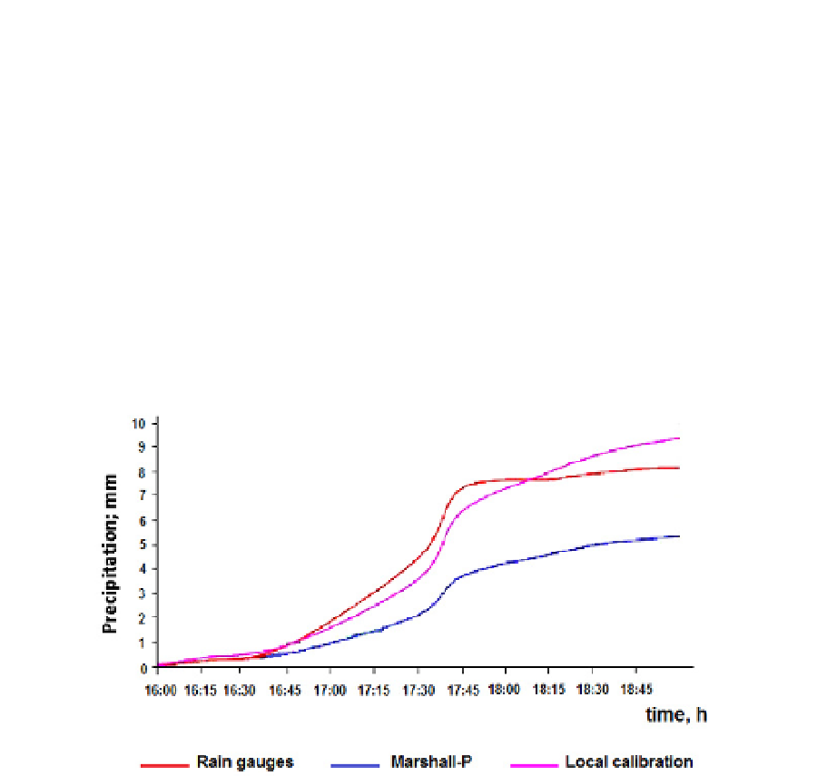
Currently all Mexican radar precipitation estimatives use the Marshall-Palmer equation
(Marshall and Palmer, 1948), which presents certain discrepancy for tropical regions (Fig. 7).
However, the precipitation underestimation could also be associated to beam overshooting,
attenuation or hardware calibration issues. A local calibration was performed in order to
improve the rainfall estimation taking into account characteristics of precipitation system
over Mexico (Mendez et al., 2006). The resulting local calibration improves the estimation of
rain (Fig. 7). Although false echoes treatment is not yet done, one might think that it can
improve even more if they are removed.
Fig. 7. Storm rainfall of 27 September 1998.
It should be mentioned the radar estimates reproduce well the precipitation patterns in time
but not quantitative ones. This new calibration distribution improves this estimate.
4.1 Hydrological analysis
The improvement in the unitary hydrograph of the basin is clear (Fig 8). This is an
expected result if one notices that the radar initially reproduce the temporal variability of
rainfall and subsequently, after calibration hydrology, quantitative estimate improves. It
is obvious that the radar properties would be underused in aggregated hydrological
models because the ability to detect the precipitation spatial variability usually are not
take into account in these models and, thus the analysis of the hydrological processes
within the basin. However, an analysis of the aggregated model applied here is
performed to detect the advantage of the radar data for hydrological model in an
experimental urban catchment.