Image Processing Reference
In-Depth Information
Table 4.1
A land cover classiication scheme for urban environments
Level 1
Level 2
Level 3
Built up
Buildings/roofs
Composite shingle roof
Gravel roof
Metal roof
Asphalt roof
Tile roof
Tar roof
Wood shingle roof
Transportation areas
Asphalt roads
Concrete roads
Gravel roads
Parking lots
Railroad
Other built surfaces
Tennis court
Basketball field
Vegetation
Green vegetation
Non-photosynthetic vegetation (NPV)
Non-urban bare surface
Bare soil
Bare rock
Water bodies
Natural/quasi-natural water bodies
Swimming pools
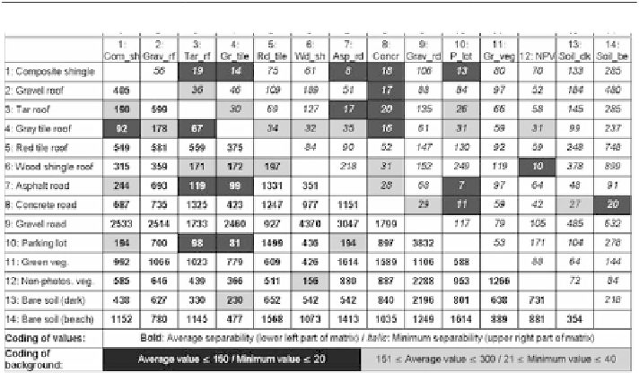
Fig. 4.4
Matrix of B-distance values for minimum and average spectral separability between different
urban land cover types derived from the Santa Barbara urban spectral library (Herold et al.
2004
)
or derived from sample areas in remote sensing image data. This spectral separability
technique calculates the spectral distance for all samples of a class to the ones of
another category. The result is an average and minimum separability score between
these two classes with higher B-distance values reflecting larger spectral separa-
tion. The resulting matrix in Fig.
4.4
containing the separability scores for several
urban land cover types are presented in Table
4.1
.