Image Processing Reference
In-Depth Information
by the measuring network, a set of satellite images (Landsat and SPOT) and a geo-
graphical database of the French Geographical Institute (IGN), the so-called BD
TOPO© (Weber et al.
2001
).
The agency controlling air pollution, ASPA (Association pour la Surveillance
et l'étude de la Pollution atmosphérique en Alsace), is in charge of 32 measuring
stations within the Alsace region with a subset of 14 dedicated to the Strasbourg
area. The pollutants measured are SO
2
, NO
x
, CO, CO
2
, O
3
, PM
10
and PM
2.5
. All
measures are available every 15 min and allow continuous study and surveillance
of local air pollutants concentration. The set of satellite images is composed of
eight Landsat scenes and a SPOT scene acquired at different seasons between
1998 and 2001. The geographical database BD TOPO© is georeferenced and con-
tains the land use, streets network, railway network, built-up areas, building heights,
hydrological information, topography, and administrative limits
From this set of data, ID cards of the urban area are built for each available satel-
lite image. Apart from the spectral signatures, these ID cards include morphological
descriptors such as spots measurements descriptors, urban spot descriptor, geomet-
ric descriptors, volumes descriptors (Weber et al.
2002
; Basly
2000
). A part of the
ID card is stable regardless of the acquisition date of satellite images, an other part
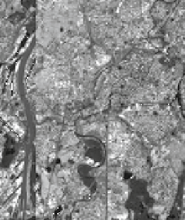
is dependent on the images itself. For a given data, a classification of the ID cards
is performed and similitude with IDs of the actual stations determines the pseudo-
stations (Fig.
11.8
). Some artifacts appear because of incomplete ID cards and
should be removed.
An example of pseudo-station relating to the actual station, the STG Centre
2 station, is presented in Fig.
11.9
. Figure
11.9a
is a superimposition of the
pseudostations
Measuring stations
Classification
Fig. 11.8
Location of pseudo-stations after classification of the ID cards