Image Processing Reference
In-Depth Information
disturbances from the target environment can be incorporated via a window-based
determination of scattering processes. Aerosol scattering in the shorter wavelength
regions is corrected by applying pre-defined aerosol models and distributions along
with appropriate aerosol scattering functions. The most problematic factor is the
water vapor content that varies over short distances. As hyperspectral data sets are
spectrally quasi-continual measurements including water vapor absorption bands,
it is possible to determine the water vapor quantities by analyzing the absorption
bands at wavelengths of 940 and 1,140 nm, which correlate well with water vapor
quantities. A pixel-wise water vapor estimate from the image itself can hence be
included in the correction process (Gao and Goetz
1990
).
Finally a correction of topography effects is necessary to precisely account for
illumination dependent differences. Direct and diffuse illumination along with shading
effects largely varies the target reflectance properties. In an urban environment, the
influence of topography and the influence of the built environment are to be distin-
guished. The first can be included via aspect, slope, shading, and visible sky view
properties extracted from a digital elevation model (DEM). However, large scale
geometric properties, such as building height or roof angles, are only provided by
precise digital object models (DOM). Such models are available from high resolu-
tion stereo data, light detecting and ranging (LIDAR), or interferometric synthetic
aperture radar (IFSAR). Though, state-of-the-art techniques do not yet allow for a
geometric co-registration of these models and hyperspectral data in the cm-range,
which would be necessary to apply the appropriate calculations. Nevertheless, a
parametric radiometric pre-processing relying on an adequate parameterization of
atmospheric parameters and including a DEM is the most accurate way of radiometri-
cally correcting hyperspectral imagery (Fig.
9.2
).
9.2.2
Geometric Correction
The geometric correction of airborne hyperspectral scanner data is similar to the
geometric correction of multispectral scanner data apart from the amount of spectral
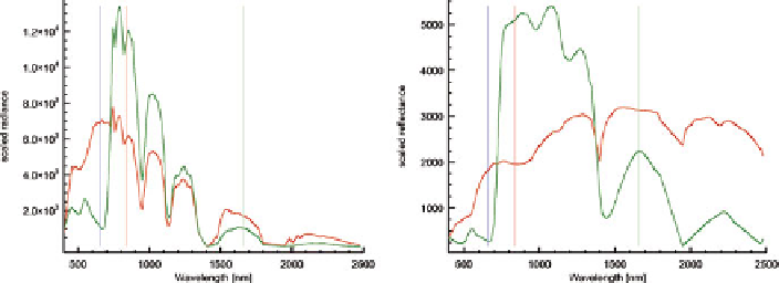
Fig. 9.2
Spectral comparison of paving stones and photosynthetic active vegetation from HyMap
imagery before and after parametric radiometric correction