Travel Reference
In-Depth Information
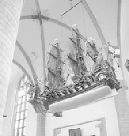
merchant vessels, protecting
them from pirates in their two-
year journey to the Far East
and back. This one has a f lat-
bottomed hull, necessary to ply
Amsterdam's shallow harbor. It
could f fire a 21-gun salute from
each side. Extra cannons on the
poop deck and forecastle made it
more powerful than the average
frigate. The keel has an iron saw,
a Dutch military specialty for
slicing through the chains that commonly blocked harbors (see the
chain between two towers near the bow).
• Three yards away, just to the right, find the...
Memorial to Hydraulic Engineers
The marble relief shows Neptune in his water chariot. In low-lying
Holland of the 1800s, when flooding could mean life or death,
hydraulic engineers were heroes.
Twenty yards beyond the memorial (near where you entered,
just left of the café) is a painting done when the church was com-
missioned. This provided a model for the architects to follow.
• From here, circle the church counterclockwise, starting back near the
tourists' entrance. On the wall near the tourists' entrance hangs an...
Old Map of “Harlemum”
The map shows the walled city in 1688, with ramparts and a moat.
Surrounding panels showcase Haarlem's 750-year history. The
lower-left panel shows the 1572-1573
Siege of Haarlem (described below),
as brave Haarlem women join their
menfolk in battle—bombs exploding
around them—to fight off invading
Spanish troops.
The bottom-right panel shows
knights kneeling before a king in the
12th century, while in the distance,
ships sail right along the city walls.
Up until the 1840s, when it was drained and reclaimed, there was
a large lake (the Haarlemmermeer) standing between Haarlem
and Amsterdam (see page 210). The Grote Kerk, when viewed by
distant travelers, seemed to float like a stately ship on the lake, as
seen in the landscape along the bottom of the map.
• Circle around the altar to the other side of the church, to...