Information Technology Reference
In-Depth Information
Bonfire Character
on Mt. Daimonji
Viewing spot
(Demachi-yanagi)
Current view
Simulated view with buildings
with potentially maximum height
before the new height regulation
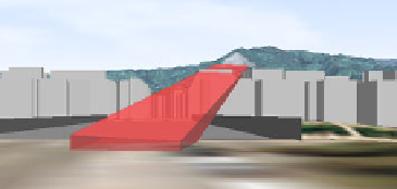
Fig. 6.
Evaluating potential risk of obstructed view from possible development
Demachi-yanagi, the meeting point of the Kamo and Takano rivers, is a popular
viewing spot to see the first bonfire lit on the hillside of Mt. Daimonji (Nyoigatake).
Virtual Kyoto was applied to evaluate the potential risk of obstructing this view due
to possible future development of buildings with the maximum height allowed under
the previous building and development regulations. In Fig. 6, a red half-transparent
board represents the vista line from the viewing spot to the fire bed of the bonfire
character.
While no building height currently exceeds the line, the clear view could
potentially be obstructed by future development and buildings that comply with the
building height restrictions (see the bottom image in Fig. 6). To avoid such potential
destruction of historical views in Kyoto, the Kyoto City Government initiated a new
landscape policy in 2007 (the Kyoto City Landscape Policy)[13], to protect the
beautiful historical urban landscape of the city. The policy puts direct control on the
appearance and height of buildings from four aspects: height restriction in the city
centre; conservation of scenic views and 'borrowed landscapes' from certain viewing
spots; design restrictions on buildings; and regulation against the display of outdoor
advertisements. Following this new scheme, 38 magnificent vistaed views and
'borrowed landscapes' were designated as heritage views to be conserved and new
height regulations based on altitude were introduced, with the help of landscape
simulations, so as not to hamper those significant vista.