Geology Reference
In-Depth Information
runs approximately E-W, or approximately along
dip during Pennsylvanian deposition. Modern
feeder streams have carved secondary canyons
that intersect the main river canyon at near right
angles, which locally provides a means to observe
the distribution of mounds in the strike dimen-
sion. Along such a secondary stream channel at
8-Foot Rapids (Wildhorse Canyon), it is possible
to walk-out and follow the rapid change from the
10-12 m high mounds/dunes exposed along the
main river as they pinch out within just a couple
hundred metres to the south. This type of rapid
reduction in large sand waves/dunes would be
expected near the edges of the tidal channels and
passes, and is similar to what is observed near
Halfmoon Shoal. Unfortunately, the distribution
of the mounds to the north of 8-Foot Rapids, which
would be towards the other side of a hypothe-
sized tidal pass, is unknown as the section is not
exposed by the river or subordinate streams.
The many similarities between the large sand
waves forming in the Quicksands area and the
Paradox mounds at 8-Foot Rapids strongly sug-
gest that the phylloid 'mounds' might have been
deposited as sand waves or dunes within a tidal
channel or pass (Fig. 11). Such an interpretation
could have a signifi cant effect on the exploration
strategies employed within the basin for algal
mound reservoirs. The distribution of relatively
small satellite fi elds within the Paradox Basin,
which are typically 1-2 km wide and 3-5 km long,
have previously been interpreted as being associ-
ated with deep-seated structural trends, and are
mapped and explored for accordingly. Whereas
there is most likely a structural component to
these near-dip oriented fi elds, based upon the
abundant subsurface data that has been studied to
date, the possibility of tidal pass concentration of
algal mounds should not be discounted.
LST to Early TST
T
5
Late HST
T
4
T
4
HST
T
3
T
3
Tidal Pass/Channel
Middle TST
T
2
Early-Mid TST
T
1
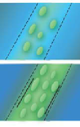
Fig. 11.
Diagram showing model for development of
phylloid algal mounds/dunes in a tidal channel or tidal
pass. Mound distribution would be elongated in dip direc-
tion and relatively narrow in strike dimension (hundreds
of metres to few kilometres). The diagram shows the sand
waves/dunes initiating during the early to middle TST as
the platform becomes fl ooded to a point where tidal cur-
rents start to develop (T
1
and T
2
). The bases of the dunes
in this model are muddier than later when the tidal cur-
rents reach higher velocities. The algal dunes, consisting
primarily of phylloid algal plates, form during maximum
tidal fl ow during highstand (T
3
). As available accommoda-
tion space becomes more limited during the latest high-
stand (T
4
), the topographic lows between the dunes would
become fi lled with more diverse shallow-marine skeletal
grains from nearby areas. In the Paradox Basin example dis-
cussed here, lowstand results in exposure of the mounds,
followed by a capping of the cycle with siliciclastic sands
CONCLUSIONS
currents would provide not only another possible
mechanism to explain the formation of these Late
Palaeozoic mounds, but could be signifi cant to
exploration geologists searching for mounds that
are hydrocarbon reservoirs (see Table 1). In contrast
to the standard model of broad shelfal distribution
of algal mounds, those emplaced through the work
of tidal currents are most likely going to be in rela-
tively narrower belts that are oriented primarily in
a dip direction. Realization that these important
hydrocarbon reservoirs may have multiple orien-
tations may prove to be a valuable tool in many
hydrocarbon basins throughout the world.
The striking similarity of the phylloid algal mounds
exposed along the San Juan River to the sand waves
reported by Shinn
et al
. (1990) in southwestern-
most Florida (i.e. in grain size, shape, allochem
distribution, platy component abundance and
near sinusoidal distribution, as well as amplitude
and wavelengths of the individual mounds), sug-
gests that the mounds exposed along the river near
8-Foot Rapids may have also been deposited in
response to tidal currents. The formation of phyl-
loid algal mounds due to hydrodynamic emplace-
ment of algal plates moved by high-energy tidal