Geology Reference
In-Depth Information
(a)
Fig. 8.
High-resolution single-channel seismic profi le from
Shinn
et al
. (1990) showing large (5
m high) sand waves
that are migrating across the bottom of a tidal channel just
west of Halfmoon shoal. Sand waves are forming in depths
of about 12 m. Arrow indicates Pleistocene bedrock surface
as originally illustrated by Shinn
et al
. (1990).
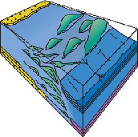
Algal Mound
- Patch Reefs
(b)
(a)
Algal Dunes
/Sandwaves
(b)
Fig. 10.
Schematic diagrams (a,b) illustrating variations
in algal buildups that form through commonly accepted
baffl ing and binding (a) and as a result of tidal currents
building sand waves or dunes. In the classic model, phyl-
loid algal mounds are formed by a combination of baffl ing,
binding and syndepositional marine cementation. These
mounds are distributed much like other patch reefs, and
would extend preferentially along strike. In contrast, phyl-
loid algal sand waves forming in tidal channels or passes,
would be much more limited aerially, and found in belts
that are dip-elongated with widths along strike varying
from hundreds of metres to a few kilometres based upon
modern examples.
Fig. 9.
(a) Photograph showing living codiacean (green) alga
Halimeda
sp. (b) The white sands are from the Quicksand
area and are comprised mainly of disarticulated plates
from
Halimeda
sp. The plates are released from the living
organism upon death, or due to storms, etc. that break off
part of the alga.
Of particular interest is that such a mechanism
would provide a new model for the formation of
some of the Paradox algal mounds, while also pro-
viding support for the few studies to date which
have suggested a similar genetic process in phyl-
loid mounds in other parts of the world (Hamblin,
1969; Heckel & Cocke, 1969; Giles & Soreghan,
1999; Samankassou & West, 2003). In addition, if
some algal mounds form within tidal channels or
passes, it could change the way that exploration
models are developed for some fi elds. Instead of
following regional structural trends, or mapping
mounds as a series of 'patch reefs' that are widely
distributed across a shallow carbonate platform,
mound fi elds that develop in tidal channels or
passes will be located within a relatively narrow
belt that is oriented roughly perpendicular to the
strike of a platform (Fig. 10).
There are a number of similarities between the
modern sand waves forming in the Quicksands
region and the Upper Carboniferous phylloid algal
mounds exposed along the San Juan River. In both
locations, large mounds/sand waves are made up
primarily of coarse, platy carbonate grains that range
from coarse grained sand to gravel size. Based on
the common interpretation that
Ivanovia
, the most
common phylloid in the Paradox Basin, is related to
the modern codiacean alga
Halimeda
, it is likely that
the hydrodynamic behaviour of these two types of
platy carbonate grains would be very similar under
similar current conditions. Whereas plate-like algae
is the dominant grain type in both locations, the sub-
ordinate grains are also similar and characterized
by a diverse, shallow-marine biota. In the Paradox
region, the mounds/dunes are interpreted to have
formed in water depths of 12-15 m, while the larger
Holocene sand waves in the Quicksand region are
being deposited in depths of about 10-12 m.
In addition, Grammer
et al
. (1996, 2000) sug-
gested that the algal mounds near 8-Foot Rapids
were probably distributed in an elongate, roughly
dip-oriented trend that was about 1 km wide by
3-4 km long, similar in scale and geometry to the
main tidal bar belts near Halfmoon Shoal. In the
Paradox example, the present-day San Juan River,
and therefore the outcrop of exposed mounds,