Geology Reference
In-Depth Information
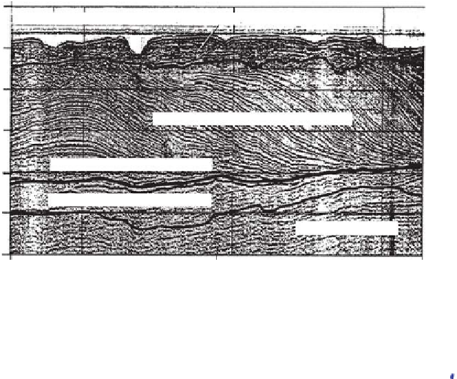
W
E
0
Undifferentiated Holocene, Pleistocene and Pliocene alluvium marl
10
20
Peace River Formation (deltaic facies)
30
Pliocene-Miocene boundary
Fig. 11.
Seismic line from lower
Charlotte Harbor at the west end of
the Caloosahatchee River reveals pro-
grading clinoforms form a deltaic lobe
as part of the Peace River Formation.
This is the lithostratigraphic unit that
fi lls in most of Charlotte Harbor (from
Missimer & Gardner, 1976; Missimer,
1999).
40
Peace River Formation (lower)
50
Arcadia Formation
60
0
1000
2000
Distance
San Carlos
Bay
Moore
Haven
Franklin Lock
La Belle
Ortona Lock
Fort Myers
0
50
Lower Peace River Formation
100
150
Arcadia Formation
200
Suwannee Formation
250
Fig. 12.
Interpreted seismic line from Charlotte Harbor to Lake Okeechobee extending west-to-east approximately 50%
across the State of Florida. This line reveals two sub-basins separated by an elevated area of the Arcadia Formation. The
western, smaller sub-basin is Charlotte Harbor and illustrates the deltaic lobe shown in Fig. 11. The much broader and
deeper eastern sub-basin also reveals much higher relief deltaic prograding clinoforms of the upper Peace River Formation.
This is the start point of the 200 km long southward delta migration as described by Cunningham
et al
. (2003).
from differential subsidence associated with
passive margins facing the Atlantic and the Gulf
of Mexico (Klitgord
et al
., 1988; Sawyer
et al
.,
1991). Indeed, relatively minor seismic activity
(earthquake magnitudes <6.0) is ongoing
throughout the eastern Gulf of Mexico and
Florida Platform region (http://earthquake.
usgs.gov/eqcenter/eqinthenews/2006/usslav/).
Nevertheless, differential geothermal gradients
setting up Kohout-style convection (Tanner, 1976;
Fanning
et al
., 1981; Kohout
et al
., 1977, 1988;
Mitchell-Tapping
et al
., 1999; Mitchell-Tapping,
2002) mixing ground-waters of different salinities
and carbonate saturation states possibly produced
selective dissolution of carbonate or evaporite
rocks, or both.
Much of the high-resolution seismic refl ection
profi ling on the Little and northern Great Bahama
Bank, and Cay Sal Bank presented here reveals
no sub-basins or subsurface deformation in the
shallow stratigraphy (Hine & Neumann, 1977;
Hine, 1977; Hine
et al
., 1981; Hine & Steinmetz,
1984). Admittedly, there are large gaps in the
data coverage and most seismic lines were run
across the margins of these huge, modern carbon-
ate platforms. However, there is a complete lack
of deformation anywhere, even in the interior
seismic lines and even in deeper penetrating
seismic data (Eberli & Ginsburg, 1987; Ginsburg,
2001). Perhaps, the fact that the Bahama Banks
are isolated and detached as compared to the
Florida Platform with its main aquifer system
extending into the southeast USA presents a fun-
damental difference (http://capp.water.usgs.gov/
gwa/ch_g/G-text7.html)? During lowstands of sea
level, the Florida Platform still received ground-
water infl ux from the northern components of
the Floridan Aquifer allowing for continued or