Geology Reference
In-Depth Information
N
W
E
S
5 0
5
10
km
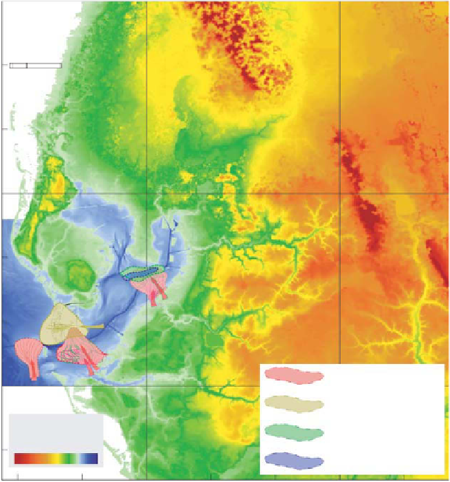
Fig. 6.
Terrain model map (USGS)
showing rivers and point sources of
prograding sequences in Tampa Bay
aligned with the modern drainage
system. The ancestral counterparts
provided the source of siliciclastic
sediment that fi lled in the Tampa Bay
sub-basin.
m
W
W
Similarly, these smaller sub-basins have been
fi lled in with at least six sedimentary sequences
that are identifi ed and mapped by their bound-
ing unconformable surfaces seen in seismic data
(Evans, 1989). These late Neogene to Quaternary
sequences are siliciclastic with three Quaternary
seismic sequences, based upon the analysis of
40 short (<6 m long) vibracores, consisting of
lithological units dominated by mud, shelly sand
and quartz gravel. These sediments mostly refl ect
fl uvial to upper estuarine, lagoon and tidal-inlet
depositional environments (Evans
et al
., 1989).
In the southern portion of the Charlotte Harbor
estuary near the Caloosahatchee River, lies a pro-
grading deltaic lobe (Fig. 11) interpreted to be
part of the Peace River Formation overlying the
Arcadia Formation based on seismic data gath-
ered by Missimer & Gardner (1976), Missimer
(1999), and Cunningham
et al
. (2001b, 2003).
This information combined with seismic data and
borehole chronostratigraphy by Cunningham
et al
.
(2001b, 2003), indicate that much of the late
Neogene and early Quaternary seismic sequences
mapped by Evans
et al
. (1989) are the late Miocene
to early Pliocene Peace River Formation - same as
in the Tampa Bay sub-basin. Seismic data indic-
ate a greater presence of Quaternary cut-and-fi ll
palaeochannels in the seismic sequences beneath
Charlotte Harbor than in their counterparts
beneath Tampa Bay, suggesting greater palaeofl u-
vial activity.
Finally, an interpreted seismic line (Fig. 12)
extending from the Charlotte Harbor sub-basin
to Lake Okeechobee run in the Caloosahatchee
River illustrates the deformation within the
underlying Arcadia Formation that forms a seis-
mic basement high separating two distinct sub-
basins. Both basins are fi lled with prograding
clinoforms typical of delta lobes. The clinoforms
in the eastern sub-basin have up to 100 m of relief,
indicating that a delta lobe prograded into water
of at least that depth. Borehole data adjacent
to the Caloosahatchee River verify a delta
depositional environment (Cunningham
et al
.,
2003). This large delta is the northernmost extent
of the palaeofl uvial and deltaic depositional