Geology Reference
In-Depth Information
Cotton
Hole
Boiling
Hole
Glass
Window
N
Goulding
Cay
25
o
10'N
ELEUTHERA
Fig. 10.
Oblique aerial photograph of the southern Exumas
showing Norman Ponds Cay (NPC) and Lee Stocking
Island (LSI). Note extensive ooid shoal on the bankward
side of the tidal channel between the two islands. Despite
the presence of this ooid factory, beaches on the windward
side of LSI are characterized by bioclastic sand. Photograph
courtesy Paul J. Hearty.
10 km
76
o
30'W
Stage 7
bioclastic calcarenites
Stage 9 / 11 oolites
Recent washovers
Stage 1 units
Substage 5a
bioclastic calcarenites
Substage 5e oolites
? Stage 13
bioclastic calcarenites
currents over the ebb-tidal currents. For example,
Lily Bank on the northern edge of LBB (Hine,
1977) clearly shows a fl ood or bankward domi-
nance of bedforms, and sand-body geometric fea-
tures such as bankward-oriented spillover lobes.
Given an appropriate track, a hurricane could
produce much stronger easterly fl ows that would
transport lagoonal sediments eastward through
the inter-island gaps and place these sediments
in the windward environment for dune develop-
ment. However, such an event is probably rare.
Hurricanes pass by quickly, and there is simply
not enough time to transport signifi cant quanti-
ties of sand over long distances (at least several
kilometres, but probably tens of kilometres) in a
3-4 hour time frame. This model does not appear
to be the solution to explain the presence of
extensive Pleistocene oolites on the windward
islands.
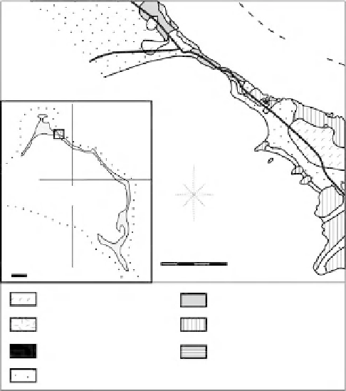
Fig. 11.
Geological map of the Boiling Hole area (modifi ed
from Kindler & Hearty, 1997). Dotted line in inset is the
200 m isobath.
Fig. 12.
View of the southeastern end of the Boiling Hole
outcrop showing two stacked Late Pleistocene oolites
(units 2 and 3) onlapping a skeletal aeolianite of Middle
Pleistocene age (unit 1). Unit 3 beach deposits (upper right-
hand side) show low-angle cross beds that dip towards
the southwest indicating that constituent particles were
formed on and transported from the bank interior.
Bank-side production and eastward transport
of ooids
In the fourth and last model, ooids were formed
on the bank interior and transported directly onto
the islands by a westerly energy fl ux. The Boiling
Hole section in northern Eleuthera (Fig. 11) rep-
resents a good illustration of such a case. At
this location, oolitic limestones dating from the
last interglacial (Kindler & Hearty, 1995; Hearty,
1998) partly fi ll a large depression between two
~20-m-high aeolianites of Middle Pleistocene age,
and are capped by MIS 5a dunal deposits (Fig. 3b
in Kindler & Hearty, 1997). New observations at
the southeast end of this swale reveal that (1) the
MIS 5e oolites consist of two shallowing-upward
sequences including subtidal, beach and aeolian
deposits, separated by an erosional surface (Figs 12
and 13), and (2) both beach and aeolian bed sets
dip towards the southwest, i.e., the bank interior.