Geology Reference
In-Depth Information
Conch
Bay Point
Bannerman
To w n
BIG
POND
Black Bay Point
WHITE
POND
Big Bluff Point
24˚37'N
N
Lighthouse
Joe Thompson Point
Eleuthera, or
East End Point
0
0.5
1 km
76˚10'W
Fig. 3.
Topographic map of East End Point, southern
Eleuthera showing the NNW-SSE-trending, middle
Holocene ridge between Big Pond and the North Atlantic
shoreline. The ridge crest is located at about 4 km to the
west of the bank margin.
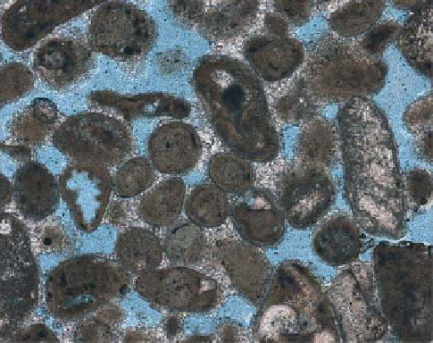
Fig. 5.
Oolitic grainstone collected from the East End Point
ridge (sample EL 201). Abundant superfi cial ooids, good
particle preservation, and minor low-Mg calcite meteoric
cement characterize this middle Holocene unit.
freshwater cementation processes (Halley & Harris,
1979; Kindler & Mazzolini, 2001).
To determine if it was possible to generate suf-
fi cient oolitic sand on a narrow shelf during a
high-frequency sea-level event, the following sim-
ple assumptions and calculations are presented.
Based upon fi eld observations, we assume that
each Pleistocene cycle would produce a 6 m
thick aeolian deposit that would extend 1 km
across an island such as Eleuthera. This pro-
duces a volume of 6000 m
3
if we make our cross-
section to be 1 m wide. Now let us assume that
the adjacent shelf was 1 km wide and oolitic
sediments were generated over a 6000 yr time-
frame before production shuts down. Sea-level
curves indicate that the narrow (1 km wide) shelves
fronting much of Eleuthera Island, for example,
were fl ooded since 6 ka or earlier. Thus, 6000 m
3
of sediment would have to be produced across a
strip on the shelf that is 1 km by 1 m or 1000 m
2
over 6000 years, or 1000 m
3
1000 yr
1
over this
same strip of shelf. This converts to 1 m
3
yr
1
over
1000 m
2
and further converts to 0.001 m
3
yr
1
m
2
.
So, how thick is 0.001 m
3
when spread over 1 m
2
?
By converting to centimetres, it is 0.1 cm. So, we
need a production rate of 0.1 cm yr
1
over a 1 km
wide shelf for 6000 years. Can oolitic sediments be
generated this fast? According to Schlager (1981),
such sediments can be produced at rates ranging
from ~40 to ~110 cm 1000 yr
1
. To make the calcu-
lations simpler, let us choose 100 cm 1000 yr
1
or
0.1 cm yr
1
- the same number we just calculated.
Fig. 4.
Partial view of the East End Point oolitic ridge
looking towards the south. The large, westward-dipping,
aeolian foresets disappear beneath modern, bioclastic,
beach sands, indicating that (1) the dune was deposited
when sea level was slightly lower than present, and that
(2) there was an ooid factory to the east of the island.
just offshore, as is the case near the Joulters Cays
today. Ooid production stalled during the late
Holocene, probably because of increasing water
depth on the outer platform due to the ongoing
transgression. Nonetheless, this depositional sys-
tem was able to build up a 15-m-high oolitic ridge
in about 1700 years, i.e., between the onset of open
marine conditions on the bank about 4.7 ka ago
(Hine, 1983) and the end of ooid production about
3 ka ago (Kindler, 1992, 1995). This oolitic ridge was
then preserved due to the rapidity and effi ciency of