Environmental Engineering Reference
In-Depth Information
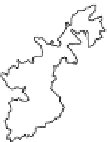
0
10 km
0
100 km
Lake
NIGERIA
CHAD
C A R
CAMEROON
KUMBO
ATLANTIC
OCEAN
Mt. Oku
EQU L
GUINEA
GABON
CONGO
s
n
d
a
BAMENDA
l
h
g
i
H
a
d
n
m
e
a
B
KEY
Forest cover
Land over 1800m
Source:
BirdLife International - Cameroon Highlands Project.
Figure 3.5
Location of forest patches that form part of the Bamenda
Highlands ICDP network, within the geographical extent of
the Cameroon Highlands
government, for several decades) or to support conservation without an
oi cial protected area that was based instead on community agreements
and sustainable use of forest resources. When the project started in 1987,
the i rst step was to agree and demarcate a forest boundary. This was
urgently needed to avoid further loss to encroaching farmland, and the
project worked closely with community leaders to agree a boundary that
was then marked with
Prunus africana
trees. In these earlier phases, the
project focused on education and awareness, sustainable use of forest
products (especially honey) and a 'livelihoods' programme that aimed to
assist farmers to improve production on their farmlands bordering the
forest. Following the passing of a new Forestry Law in 1994, the Kilum-
Ijim Forest Project started a major new phase, in which the focus became
support to decentralized forest management by adjacent communities