Geography Reference
In-Depth Information
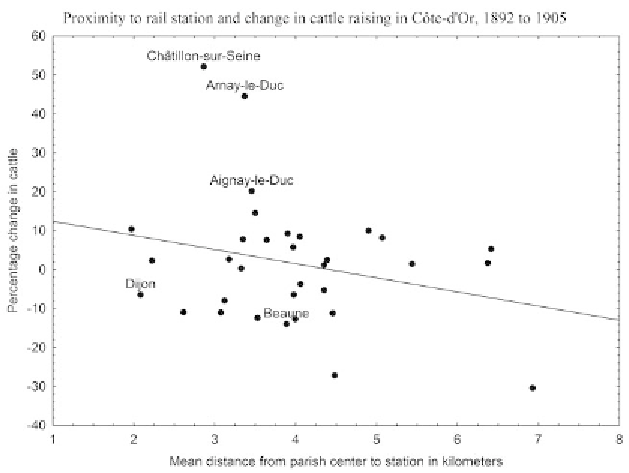
1.9.
Proximity to railway station and change in catle raising in Côte-d'Or, 1892-1905.
Sources:
6M 12, IIa31, IIa37, IIa50, Statistique agricole des communes et cantons, 1881,
1892, 1905, Archives Départementales de la Côte-d'Or;
Carte des chemins de fer français,
SNCF, 1944, Ge BB 368, Bibliothèque Nationale de France.
In catle raising, percentage changes from 1892 to 1905 ranged from
positive increases to steep declines, and there was an inverse relationship
with mean distance from a commune to a station (see figure 1.9). By and
large, the greater the accessibility (shorter distance), the greater the in-
crease in livestock numbers; conversely, the lesser accessibility (greater
distance), the smaller the density of catle in 1905 as compared to 1891.
his patern was more pronounced in upland areas than in the plains. In
contrast to the plains of Dijon and eastern Beaune, where wheat farming
was expanding, in the upland cantons of Châtillon-sur-Seine, Arnay-
le-Duc, and Aignay-le-Duc, catle farming was expanding signiicantly.
In 1905 compared to 1892, upland farmers who were relatively close to a
station (one or two miles) were typically raising more stock than those
farther away. In so doing, they followed a national trend and depended
upon rail transport to adjust to the shifting conditions of markets for