Geography Reference
In-Depth Information
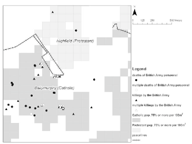
3.9.
Large-scale map showing an interface area of West Belfast overlaid with
locations of fatalities of and by British Army personnel during the Troubles.
A final map display serves to show that religious geographies influ-
enced the occurrence of other fatalities and the shape of the Troubles
more generally. The map in figure 3.9 focuses in on a highly contested
interface area of West Belfast between the Protestant Highfield and Cath-
olic Ballymurphy areas. The same shading has been applied to 100-by-
100-meter grid cells as in figure 3.8. Here, however, the goal is not to
smooth a general surface; instead, point symbols representing locations
of individual killings are retained in the display. These locations are for
fatalities among and commited by the British Army, which was heavily
deployed in Catholic areas as the threat from the PIRA and other repub-
lican splinter factions intensified from the start of the 1970s. Yet it must
be remembered that the arrival of soldiers in those areas was initially
seen by both the military and the resident Catholic population as neces-
sary and defensive.
40
However, just a year later the batle for “hearts and
minds” was already being lost, and the Catholic perception of the army
had already swung from friend to foe.
41
The concentration of fatalities on