Environmental Engineering Reference
In-Depth Information
TABLE 6.12. USDA Soil Separates
ground surface
Diameter
(mm)
O horizon
Separate
A horizon
Very coarse sand
2.00-1.00
Coarse sand
1.00-0.50
Medium sand
0.50-0.25
Fine sand
0.25-0.10
B horizon
Very fine sand
0.10-0.05
Silt
0.05-0.002
Clay
<0.002
C horizon
D horizon (bedrock)
accumulation and pronounced soil structure. The
C
horizon
extends from the bottom of the B horizon to
the top of the parent bedrock from which the soil
evolved by weathering. The C horizon has characteris-
tics of the unconsolidated, weathered parent material.
The A horizon is of considerable importance to
diffuse pollution since it is the layer where most adsorp-
tion and biochemical degradation of pollutants takes
place. The microbial processes by which pollutants and
nutrients (nitrogen and phosphorus) are decomposed or
transformed are confined primarily to the A horizon. A
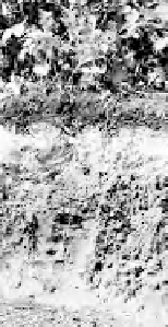
typical soil profile observed in the field is illustrated in
Figure 6.20b, where the darker portion of the soil profile
corresponds to the A horizon. Only soluble (mobile)
pollutants can penetrate deeper soil zones and eventu-
ally pollute groundwater. In most cases, the B horizon
is less permeable than the topsoil, resulting in occa-
sional
interflow,
, which is lateral flow between the A and
B horizons. Saturated zones are generally located in the
C horizon.
The infiltration capacity at the ground surface is
related to the texture of the surface soil horizon, which
is determined by the sand, silt, and clay fractions. Soils
can be divided into
soil separates
according to particle
size ranges shown in Table 6.12, and the soil texture is
determined by the relative proportions of sand, silt, and
clay using the U.S. Department of Agriculture (USDA)
soil texture triangle, shown in Figure 6.21. NRCS soil
maps and GIS databases are commonly used to delin-
eate the geographical distribution of various types of
soils. Slope classifications are frequently added as sub-
scripts to a soil series name, and the USDA slope clas-
sifications used for this purpose are given in Table 6.13.
As can be seen from Table 6.13, slope classes overlap
due to localized soil and topographic conditions. Topo-
graphic slopes are important for assessing runoff and
erosion potential in a watershed. In classifying soils, the
name of the soil reported in a soil map has two parts: a
local name and a slope. For example, in the soil map of
southeastern Wisconsin, a code RoB signifies Rosseau
loamy fine sand in the slope category B (2-6% slope).
(a)
(b)
Figure 6.20.
(a) Soil horizons, and (b) typical soil profile.
A RK LS CP
=
(
)
=
(
721 0 25 1 37 0 7 1
)( .
)( .
)( . )( )
=
173 tonnes/ha
The annual soil erosion from the 200-ha farm is
predicted to be on the order of 173 tonnes/
ha × 200 ha = 34,600 tonnes.
(b) If the delivery ratio is 15%, the sediment load on
the receiving water is estimated as 0.15 × 34,600
tonnes = 5190 tonnes.
6.3.2.2 Soil Pollution.
Chemicals used in agriculture
are a major source of soil pollution, and when this pol-
lution becomes excessive, these pollutants frequently
end up affecting water quality. The soil profile is divided
into three layers or horizons, as illustrated in Figure
6.20a. A
soil horizon
is a layer of similar soil color,
texture, structure, or porosity oriented approximately
horizontally to the Earth's surface. A soil profile typi-
cally contains a surface layer of decaying organic debris
(detritus) with little soil called the
O horizon
or organic
horizon. The
A horizon
, which is usually several centi-
meters to a fraction of a meter thick, is the soil of great-
est concern, since roots, soil microorganisms, and
organics are found there in their greatest densities. It is
also a layer of considerable leaching and is often referred
to as topsoil. The A horizon is typically scraped and sold
for lawn topsoil or stockpiled for reapplication on con-
struction sites. The
B horizon
, underlying the A horizon,
is a subsoil where most leached salts, chemicals, and clay
from the A horizon are deposited. It usually has less
organic matter and few plant roots, since only large
plants and trees have root systems penetrating subsoils.
The B horizon is commonly referred to as the
subsoil
,
and the accumulation of material leached from the A
horizon often results in a higher-density soil with clay


Search WWH ::

Custom Search