Database Reference
In-Depth Information
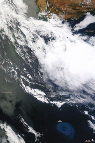
Figure 15.3.
Image from the NASA TERRA satellite showing an anti-cyclonic
(counter-clockwise in the Southern Hemisphere) eddy that likely peeled off from the
Agulhas Current, which flows along the southeastern coast of Africa and around the
tip of South Africa. This eddy (roughly 200 km wide) is an example of eddies trans-
porting warm, salty water from the Indian Ocean to the South Atlantic. We are
able to see the eddy, which is submerged
under
the surface because of the enhanced
phytoplankton activity (reflected in the bright blue color). This anti-cyclonic eddy
would cause a depression in subsurface density surfaces in sea surface height (SSH)
data. Image courtesy of the NASA Earth Observatory.
4.2 Illustrative Application: Identifying Ocean
Eddies from Satellite Altimeter Data
Coherent rotating structures of water, known as ocean eddies, are a
crucial component of ocean circulation. In addition to dominating the
ocean's kinetic energy, eddies play a significant role in the transport of
water, salt, heat, and nutrients. Therefore, understanding current and
future eddy patterns is a central challenge to addressing the sustainabil-
ity of marine ecosystems.
Our understanding of ocean eddy dynamics has grown significantly
with the advent of satellite altimetry. Prior to then, oceanographers re-
lied primarily on case studies using drifting floats in the open ocean to
collect detailed information about individual eddies such as rotational
speeds, amplitude, and salinity profiles. With the increased accessibility