Environmental Engineering Reference
In-Depth Information
Peruvian
Desert
Atacama
Desert
Monte
Extremely arid
Arid
Semiarid
Patagonian
Desert
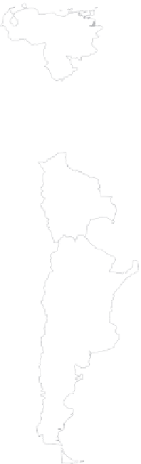
FIGURE 1.17
Arid lands of South America. (Modified from Meigs, P., The world distribution of arid and semiarid homocli-
mates, in
Reviews of Research on Arid Zone Hydrology
, UNESCO, Paris, France, 1953, pp. 203-209.)
from the Pacific on many days, providing unexpectedly high humidities. The region has
many local and regional winds, but there are very few areas of sand dunes. Nevertheless,
mobile barchans and yardangs are well developed in southern Peru.
Geologically, the region is dominated by the Andean cordillera (up to 22,800 ft asl) and,
offshore, the Peru-Chile trench (up to 25,000 ft bsl). Both features are associated with the
westward migration of the South American plate over the eastward-moving Nazca plate.
The region has abundant evidence of volcanic activity, including volcanoes, calderas,
enormous pyroclastic flow deposits (ignimbrites), lava flows, geysers, and solfatara.
102
Andesitic rocks are typical of the volcanic region, and contemporary activity is confined to
a few moderately explosive volcanoes. Tectonic activity, in the form of extensive folding and
faulting, is widespread and is responsible, inter alia, for the longitudinal differentiation of
the topography.
The principal longitudinal features of the Atacama topography (Figure 1.19) are,
from west to east, the Coastal Cordillera (up to c. 6500 ft asl); the Longitudinal Valley,
the precordillera (an area of basin-range topography, salt domes, and slopes rising up to
the Andes), and the Altiplano (an extensive, arid plateau at over 13,100 ft elevation where
volcanic activity is widespread). The Andean flanks and the Longitudinal Valley are


Search WWH ::

Custom Search