Environmental Engineering Reference
In-Depth Information
1.6 China and Central Asia
The deserts of China cover an area of around 0.43 million miles
2
and occupy about 11.6% of
the total land area of the country. They are located in the temperate zone, stretching from
75°E to 125°E and from 35°N to 50°N. Within this huge area, extreme aridity characterizes
the Taklimakan Desert (also known as the Taklamakan) of the Tarim basin. The locations
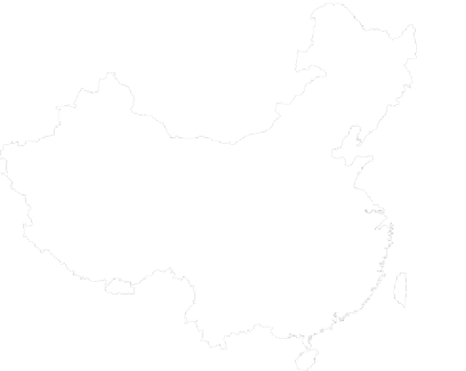
of the main desert zones are shown in Figure 1.13. They are positioned in the great inland
basins and high plateaus, with elevations generally lying between 1640 and 5000 ft,
although there are some areas, such as the Turfan Depression, that lie below sea level.
A distinction is often drawn between rocky and gravel deserts, termed “gobi,” and the
sandy deserts, termed “shamo.”
The Chinese deserts appear to be very old,
79
being formed as early as the late Cretaceous
and early Tertiary. At this time, the area was mostly under a subtropical high-pressure belt.
Late in the Tertiary, the Tibetan Plateau was uplifted and the great Himalayan orogeny
occurred. The continentality of the climate was greatly strengthened, the monsoon system
became well established, and northwestern China became even more arid. Ancient lakes in
the Tarim and other inland basins diminished or dried out gradually, and the Taklimakan
and other sandy deserts probably enlarged considerably at that time. Continued uplift of
the mountains during the Pleistocene and Holocene has further accentuated the aridity.
There is abundant evidence of climatic fluctuations during the Quaternary in the form
of very complex
loess
*
profiles, suites of old lake shorelines (most notably around Lop Nor),
Sand desert
Loess
Gobi (stony desert)
12.
M
ongolia
11.
2.
10.
8.
5.
7.
3.
4.
9.
1.
6.
Loess Plateau
Tibetan Plateau
1. Ta klimakan
2. Gurbantunggut
3. Kumtag
4. Qaidam
5. Baidain Jaran
6. Te ngger
7. Ulan Buh
8. Hobq
9. Mu Us
10. Hunshandake
11. Horqin
12. Ilulun Buir
China
FIGURE 1.13
Main desert areas of China. (Modified from
Encyclopedia of Quaternary Sciences
, Sun, J. and Muhs, D.R., Mid-
latitudes, Ed. S. Elias, p. 609, Figure 2, Copyright 2007, Elsevier.)
*
Loess deposits, which typically are spatially extensive, are aeolian deposits associated with deglaciation.


Search WWH ::

Custom Search