Environmental Engineering Reference
In-Depth Information
1964
1997
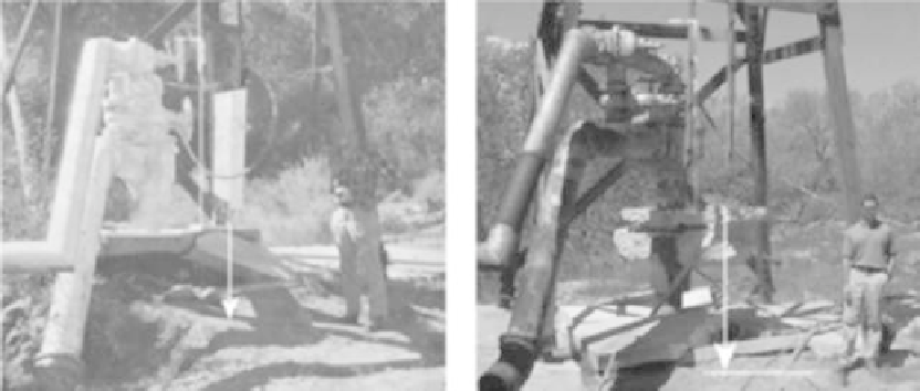
Well head
Well head
(a)
(b)
FIGURE 5.7
Public-supply well in Las Vegas, Nevada damaged by land subsidence. (Modified from Baum, R.L. et al.,
Landslide and land subsidence hazards to pipelines, U.S. Geological Survey Open-File Report 2008-1164, Reston,
VA, 2008, http://geochange.er.usgs.gov/sw/changes/anthropogenic/subside, accessed June 26, 2009.) (a) By 1964,
pumping had caused the land surface to sink from below the well head and concrete slab, which originally were
at the land surface. (b) By 1997, distance from the concrete slab to the land surface was even greater.
they compact by decreasing the pore space. This compaction results in a land surface that
is lower in elevation, usually permanently. In other words, land subsidence caused by low-
ered groundwater levels cannot be reversed by recharging the aquifer.
Land subsidence causes many problems to urban environments and infrastructure
including (1) changes in elevation and slope of streams, canals, and drains; (2) damage to
bridges, roads, railroads, storm drains, sanitary sewers, canals, and levees; (3) damage to
private and public buildings; and (4) damage to wells and casings (Figure 5.7), from forces
generated by compaction of fine-grained materials in aquifer systems.
38
In some coastal
areas, subsidence has resulted in tides moving into low-lying areas that were previously
above high tide. Earth fissures can be more than 100 ft deep and several thousand feet in
length; one extraordinary fissure in central Arizona is 10 miles long.
36
These features start
out as narrow cracks, an inch or less in width, and they intercept surface drainage and can
erode to widths of tens of feet at the surface.
In Arizona, as in other states, areas subject to land subsidence are known and mapped.*
In areas subject to subsidence from groundwater pumping, mitigation has involved (1)
reduction in groundwater pumping and switching to surface water where such supplies
are available, (2) moving groundwater pumping to areas less susceptible to land subsid-
ence, and (3) moving groundwater pumping to areas where subsidence is likely to cause
less damage. The State of Arizona has programs to map land subsidence
†
and to map
subsidence-related earth fissures.‡
‡
The relevance of these programs cannot be better illus-
trated than with the Central Arizona Project aqueduct and its interaction with subsidence
zones in central Arizona.
39
*
http://www.azgs.az.gov/EFC.shtml (accessed June 23, 2010).
†
http://www.azwater.gov/AzDWR/Hydrology/Geophysics/LandSubsidenceInArizona.htm (accessed July 7,
2009).
‡
http://www.azgs.state.az.us/EFC.shtml (accessed July 7, 2009).
Search WWH ::

Custom Search