Environmental Engineering Reference
In-Depth Information
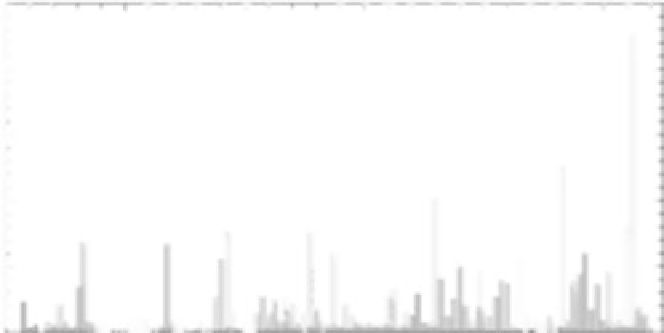
50
40
30
20
10
0
1900
1920
1940
1960
1980
2000
FIGURE 5.1
Flood damages in the United States, 1903-2007. (From http://www.nws.noaa.gov/oh/hic/flood_stats/
Flood_loss_time_series.shtml, accessed June 24, 2009.) The peak in 2005 primarily reflects damages caused by
Hurricanes Katrina and Rita.
Cruz River in southern Arizona, respond strongly to seasonal rainfall, and as a result flow
and flood records may be related to decadal-scale climatic processes.
4
In some watersheds,
such as the San Juan River, the largest floods are storm-induced while most annual peaks
are snowmelt-related.
Large rivers, such as the Colorado and Rio Grande Rivers, span a number of climatic
regimes and respond in a complex way to interannual or decadal-scale climatic processes
(see Chapter 3). For example, many of the largest floods on the Colorado River occurred
during El Niño (warm ENSO) conditions,* but some notable floods, including the largest in
the gaging record (1922), occurred during years not associated with ENSO. The Rio Grande
in New Mexico has a similar flood response to ENSO conditions, as do smaller rivers such
as the Santa Cruz River at Tucson, Arizona.
4,5
At present, our knowledge of regional hydro-
climatology is insufficient to forecast large floods well in advance, and flood-hazard analy-
ses are all retrospective and dependent upon gaging records and historical observations.
For intermediate to large channels, flood damage in the arid region results from three
interrelated effects. Overbank flooding occurs when flow overtops channel banks and
spreads laterally over the top of floodplains, inundating buildings and infrastructure. This
type of damage is the most common in most of the United States, and the National Flood
Insurance Program
6
and its flood-hazard maps
7
were developed to protect from this type
of flood impact by regulating floodplain development. While overbank flooding is com-
mon in arid and semiarid regions of the United States, the most damaging effects of floods
typically result from lateral channel change, which can destroy bridges, buildings, and
other infrastructure by undercutting their abutments or foundations. This type of damage
was particularly severe during the 1983 flood on the Santa Cruz River in Tucson, Arizona
8
and prompted continuous installation of bank protection on channels through most of
the metropolitan areas. Bank protection is now prominent along channels in the western
United States, particularly in the vicinity of bridges and other infrastructure.
*
El Niño-Southern Oscillation (ENSO) years during which large floods occurred on the Colorado and other
rivers in the southwestern United States include 1862, 1884, 1891, 1905, 1916, 1941, 1957, 1984, 1993, and 1998.

Search WWH ::

Custom Search