Geology Reference
In-Depth Information
When rivers or streams (described in Chapter 12) carry sediments from the continent to
the sea, the sediments are deposited according to their size as the motion of the water
slows down. This means that the largest, heaviest particles are deposited closest to the
seashore, while the tiniest particles are carried much farther and deposited in the deep,
still waters far from the shore.
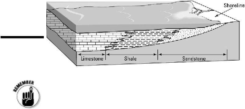
The result is that the sedimentary rocks formed in the ocean have a distinct pattern to
their particle sizes, with sandstone created closer to shore in shallow water and lime-
stone created farther away in deeper water, as illustrated in Figure 19-8.
Figure 19-8:
The
pattern of sedi-
mentary rock form-
ation in the ocean.
By understanding how the depth of the water and distance from shore affects
the type of rock formed, geologists can look at the rocks and read a story of chan-
ging sea levels.
When sea levels rise and cover more of the continent, the geologic event is called a
mar-
ine transgression.
The sedimentary rocks being deposited in one spot change from sand-
stone to shale to limestone as the water gets deeper at that location. This situation is il-
lustrated in Figure 19-9.
When sea levels drop and expose more of the continent, the geologic event is called a
marine regression.
As it occurs, the type of rocks forming in one location shift from lime-
stone to shale to sandstone as the water becomes more shallow. The rock types in a
marine regression are illustrated in Figure 19-10.
One aspect of a continent's history is found in its
cratonic sequence,
or record
of marine transgressions and regressions. North America, for example, has four
cratonic sequences dated to the Paleozoic. In each sequence, rocks indicate that