Geoscience Reference
In-Depth Information
analytic techniques for environmental assessment. Although more modern bio-
chemical methods are available, coliform bacteria and enterococci continue to
be used as indicators for the assessment of safe drinking and recreational waters
(EPA 1986, 2002, 2005), and cultivation methods for viability remain the gold
standard (Messer and Dufour 1998). In recognition of the inadequacy of the bac-
terial indicator system over the years, research methods have been developed
and improved for measuring enteric viruses (Fong and Lipp 2005; Yates et al.
2006; Pepper et al. 2010) and protozoa (Sauch et al. 1985; Rose 1988; Aboytes
et al. 2004) and for expanding the understanding of risk (Slifko et al. 1997,
1999; Aboytes et al. 2004). National surveys of groundwater and surface water
have directly influenced important rule-making, including the Surface Water
Treatment Rule, the Information Collection Rule, the Long Term Enhanced Sur-
face Water Treatment Rule, the Disinfectants and Disinfection Byproducts Rule,
the Ground Water Rule, and final rules for the use or disposal of sewage sludge.
Assessment and control of waterborne diseases still rely on the ability to
sample and quantify fecal indicator organisms and pathogens as part of the
evaluation of water quality. The most recent advances in the detection of micro-
organisms in water include quantitative polymerase chain reaction (PCR) meth-
ods, which can be designed for any microorganism of interest because they are
highly specific and quantitative. The PCR methods can produce information
relatively fast and, under the Clean Water Act and the
Beaches Environmental
Assessment and Coastal Health Act, their adoption has moved quickly toward
meeting total maximum daily load requirements and beach safety (see the ex-
ample below on “Beach Safety”).
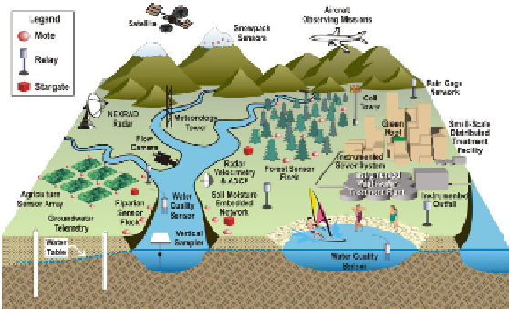
FIGURE 3-3
Schematic of an instrumented watershed in an observatory of the national
network. Real-time sensors for meteorology, rainfall, stream velocity, suspended sedi-
ment, water quality, soil moisture, groundwater, and snowpack are shown with wireless
communications equipment necessary for transmitting the data. Source: WATERS Net-
work 2009.
Search WWH ::

Custom Search