Environmental Engineering Reference
In-Depth Information
2. Meteorology, Modeling and Air Quality Data
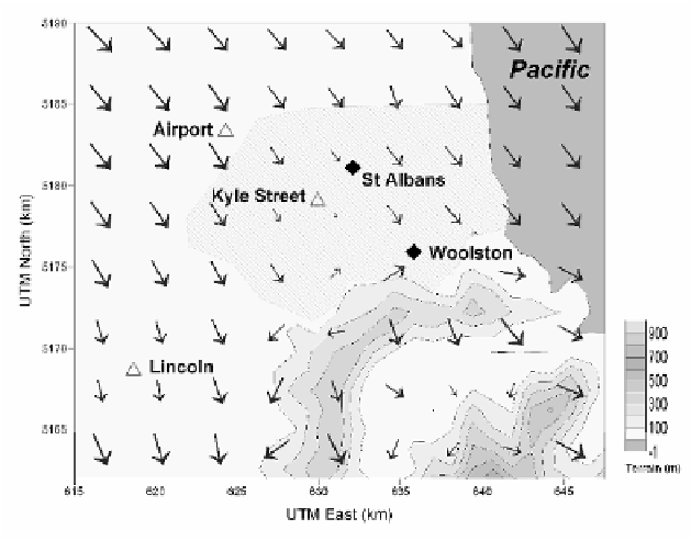
Christchurch is on the edge of the Canterbury Plains which descend gently from
the foothills of the Southern Alps over a distance of 70 km to the sea. The city is
bounded to the east by the Pacific Ocean and on the south by Banks Peninsula,
a collection of extinct volcanoes rising steeply to about 400-900 m (
Fig. 1)
.
Christchurch experiences high concentrations of PM
10
on winter evenings when
cold air drainage from the Plains results in light winds from the west-northwest [2],
concurrently there are down slope flows from the southern hills. Therefore, whilst
Christchurch itself is flat, the winds and dispersion can be affected by terrain
induced flows.
The localized terrain induced flows were simulated using the meteorological
processor, CALMET [3]. CALMET is driven by surface and upper air meteorological
data. The surface synoptic data were extracted from the national climate database
[5]. No representative upper air data are available for Canterbury, therefore TAPM
[1] (The Air Pollution Model) was used to produce point vertical profiles.
Figure 1
illustrates how CALMET can combine surface observations (Christchurch airport,
Kyle Street and Lincoln) and, on a winter night with low wind speeds, effectively
develop the down slope flows around the hills of Banks Peninsula.
Fig. 1.
CALMET representation of Christchurch surface winds, 00:00 NZST 10 July 2006. The
triangles are meteorological surface observation stations, the
diamonds
are air quality monitoring
sites and the shading is the built-up area of Christchurch. Christchurch airport wind speed 340°
0.5 m/s