Agriculture Reference
In-Depth Information
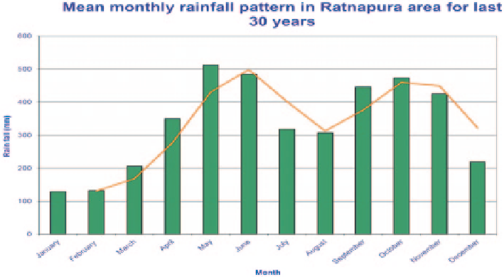
Fig. 4.3
Mean monthly rainfall pattern in Ratnapura for last 30 years. (Source: TRI)
The google earth image provided a good ready reference for the work. Various
analyses like NDVI analysis, supervised classification analysis was done on the
image using following softwares:
• ArcView GIS 3.2a
• ArcGIS 9.3
• ERDAS IMAGINE 8.5
Statistical analysis of the data for grain size was done using SIGMAPLOT software
as an extension of MS EXCEL. Besides all this softwares, handheld Garmin GPS
was used to locate the sampling location by acquiring latitudes and longitudes of
that place.
4 Result and Discussion
Red yellow podzolic (Rhodudults/ Tropudults) is the major soil group found in Rat-
napura area which is characterized by the loam to sandy loam texture at surface and
sandy loam clay in subsoil. Furthermore, soil shows higher level of gravel and lat-
erite formation. Generally, all collected soil samples show more than 97 % of sand
fraction and none of the sample yielded more than 1.5 % clay or silt. Therefore, soil
of study area is classified as sandy soil (Fig.
4.4
).
Soil organic matter content in the study area is ranging from 0.5 to 3.7 %. How-
ever most part of the study area shows less than 2 % of organic matter. Bringing a
virgin soil into agricultural use tends to destroy much of soil organic matter (Tol-
hurst
1961
), hence actual organic matter content in tea fields is expected to be low.