Geography Reference
In-Depth Information
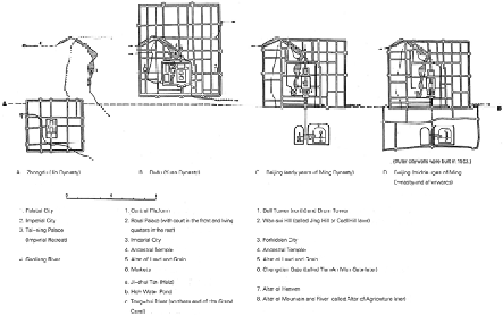
Fig. 4.1
City sites of old Beijing
(From Zhongdu City in Jin
Dynasty
to Beijing in Ming and Qing dynasties)
(
Broken line
from
A
to
B
is a reference line to demonstrate the relative positions of city sites vertically)
Qian Hai, Hou Hai and Xi Hai in the north), which is part of the general plan for
developing the new Beijing. In order to illustrate the theme of the plan of the Old
City, it's better to show the changes of watercourses and city sites of old Beijing in
the following fi gure (Fig.
4.1
).
4.2.2
Theme of City Plan
As shown in Fig.
4.1
, we see clearly that several changes in the shape of the Old
City of Beijing, from rectangular to the ingenious shape of a Chinese character
“
ࠨ
”, took place. However, the axis line running through the city from north to south,
though extended, had no sideward shift. Actually the axis line was the basis of the
surface plan of the capital. This is true of the design of the Inner City as it is of the
Outer City. It must be pointed out that even before the building of the outer walls,
two groups of architecture had been built in 1420 A.D., that is, the Temple of Heaven
and the Altar of Mountain and River (later renamed the Altar of Agriculture). They
were located symmetrically on the east and west sides of the prolonged axis line.
And with building of the outer walls in 1553 A.D., a newly prolonged central axis
line with a total length of 8 km., implicitly linking the Inner City and the Outer City,
appeared, which impressed one with the sense of unity so much that it appeared that
the two parts of the city had been planned and completed at the same time. And the
“
ࠨ
”-shaped capital, when compared with Dadu of Yuan Dynasty and Beijing in the