Geography Reference
In-Depth Information
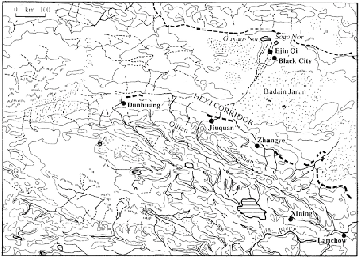
Fig. 8.1
The physical features of the Hexi Corridor
revenues, was anxious to carry on trade with the world outside. In the decade after
129 B.C. she repeatedly dispatched troops on punitive expeditions against the Huns
who fled to the north of the desert. As a result, the Han Dynasty took possession of
vast tracts of land in the Hexi Corridor and opened up a trade route leading from
Chang-an right to central Asia and Europe, thus bringing an era of prosperity to the
Silk Road.
All the while, the Huns who had retreated to the north of the desert were still
watching for an opportunity to return south. It was very easy for them to thrust into
the middle of the corridor and cut off the Silk Road, for in the central part of the
corridor the melted water running down from the north slope of the Qilian Mountains
converged into a huge river called the Ruo-shui, now also bearing the name Ejin,
which, rising approximately from 40°N latitude, flows north by east and crosses the
space between the desert and the Gobi over a span of about 300 km, and finally
empties itself by two different channels into Lake Sogo Nor and Lake Gaxun Nor
where the elevation drops to 820 m or so. Thenceforward, the terrain gradually rises
again towards the north.
This is the present pattern of surface drainage, but it was not so more than
2,000 years ago when water in the lower reaches of the Ruo-shui emptied itself into
a vast lake called Ju-yan situated further to the southeast of the above-mentioned
lakes (Fig.
8.2
). The climate at that time was also arid enough, but the Ruo-shui
River, running by different channels before it emptied itself into the lake, moistened
the land along the way and formed a delta area abounding in water and grass, with