Geoscience Reference
In-Depth Information
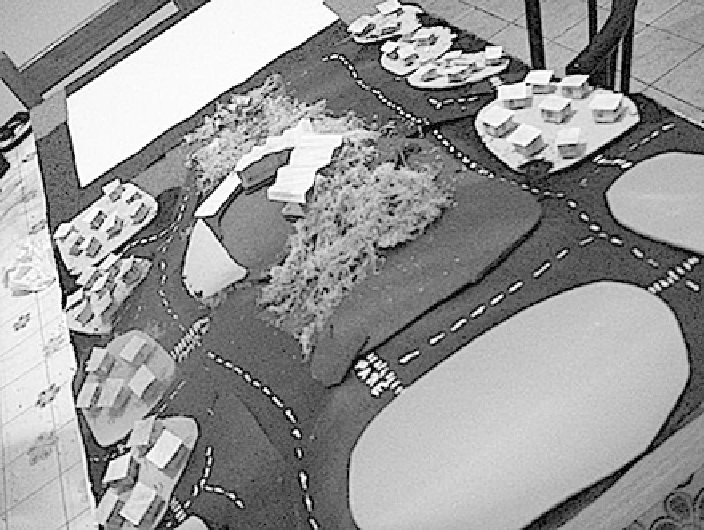
Fig. 22.13 Model of the route taken in the fieldwork
on time , the construction of the model was made by me and Carla Lombardi, the
school interpreter. The pupils then only used and explored it. In order to give them a
sense of the land level, the model was based on a 1:25,000 topographic scale of the
area. One half of the model would be the representation of the trajectory and the other
half would be a legend in 'Brazilian signs language' and in Portuguese. In order to
stimulate the implementation of the “real to the abstract”, some photos taken by the
pupils themselves were printed and glued on small polystyrene and sticks, so they
could post them on the model. Each photo was accompanied by a title in Portuguese
and in “Brazilian signs language”. Moreover, numbers were given to the pupils and
they had to put them in the model in the most appropriate place. This aimed to
encourage the pupils to look into their memories for the location of the elements
observed in the fieldwork (real) and transport them to the model (abstract).
In this activity, all pupils participated in the survey were involved together and
the activity lasted for approximately 2 h. When we discussed the application and
handling of the model, we thought that it might be best to recall them from the
pictures they took, the route taken during the fieldwork. However, to our surprise
and delight, it was not necessary. As soon as they saw the demo, the pupils were
very curious and wanted to know everything, “whether it was the school, whether it
was the neighborhood, etc
” We then began to work with each element; we asked
them to look at the legend and to try to identify the elements. Then we asked them
about the relationships by putting the number indicated in the legend (Fig.
22.14
)in
...
Search WWH ::

Custom Search