Geoscience Reference
In-Depth Information
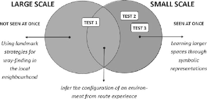
Fig. 19.2 Relation between large- and small-scale spatial abilities
large- as well as/or small-scale spatial abilities when they draw their route from home
to school. For test 2 and 3 on the other hand children would be forced to draw more
exclusively up on their large-scale spatial abilities because landmark strategies could
not help them completing this tasks.
Based on these indications of partial dissociation of large- and small-scale
spatial abilities found in Hegarty's study cited above, it is thus more likely to find
correlations between test 2 and 3 than with test 1. Children might draw a high
quality route map of the local environment using landmark strategies (large-scale
spatial abilities) but could perform much less on test 2 and 3 when their spatial
cognition is less developed.
19.3 Methodology
The study was conducted in five Belgian primary schools, three in rural and two in an
urban environment, spread over the Dutch speaking part of Belgium. 94 children (44
girls, 50 boys), aged 9-12 years, from five mixed ability classes were given approxi-
mately 30 min to complete the three tests (explained in detail in the following).
In order to achieve similar conditions in each class the test takers were given
specific instructions such as “Do not help the children in any way”; “Only explain
the task”; “Blank the map of the world if present on the classroom walls”
The
children were motivated and stimulated to take the test seriously by means of
a competition. The class with the best overall scores was promised a special prize
(
see
Fig.
19.3
).
The quality of the tests was measured via scoring tables. Each test was revised
twice by independent persons (agreement
...
85% for all three tests). The mean
scores were used for the statistical analysis (
see
1.4 Results and discussion).
>
Search WWH ::

Custom Search