Geoscience Reference
In-Depth Information
Table 13.2 Standard layers
provided by Google. All
layers are tiled
Traffic
Current traffic conditions
Photos
Locations of available photographs
Labels
Street, city, and boundary names
Webcams
Locations of cameras with live imagery
Videos
Locations of YouTube videos
Wikipedia
Wikipedia pages for locations on map
Bicycling
Biking paths and trails
Buzz
Postings to Google Buzz
45
45
degree angle bird's-eye view
Terrain
Shaded relief map
Transit
Public transportation network
+
=
Fig. 13.6 The tile overlay method. A map tile on the left is overlaid with a transparent PNG file
with an opaque line. Combining the two tiles produces the display on the right
transparent tile overlays and have a particular theme such as traffic, webcams, or
photos.
Most of the layers that are offered by online mapping services are updated only
occasionally. An example of a frequently updated layer is traffic (see top map in
Fig.
13.7
). This layer shows the speed of traffic for major streets in the larger cities
of the world and is updated continuously throughout the day. The maps are also
tiled at multiple levels of detail for faster download. Only those tiles are replaced
that need updating. The bottom map in Fig.
13.7
shows a bicycle path map that
completely covers the underlying street map, at least in urban areas. It is updated
only irregularly.
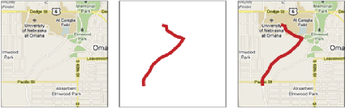
An example application of the overlay is the campus map for the University of
Nebraska at Omaha (see Fig.
13.8
). Here, a map of the campus was first constructed
with vectors in Adobe Illustrator. Subsequently, the map was converted to the raster
PNG format and tiled through an online tiling service. Three different levels of
detail of tiles were created and combined with the Google Map as a layer. Layers
were also created for parking and the shuttle transportation network.
Figure
13.9
shows how the parking and shuttle layers are integrated within
Google Maps to provide to provide an overall view of the campus. All Google
Map functions are active, such as searching for a specific location or travel routing.


Search WWH ::

Custom Search