Travel Reference
In-Depth Information
Overview
Some Tucsonans take a masochistic pleasure in running up this steep trail and pride
themselves on getting to the summit in well under an hour from the parking lot. Oth-
ers claim to climb it most days of the week to stay in shape. I prefer to take my time
to enjoy the best views in Sabino Canyon and keep an eye out for the flora and fauna.
Route Details
From the southeast end of the parking lot, the trail follows the same route as the
Phoneline Trail
for the first 1.4 miles until it reaches a junction signed “Blackett's
Ridge Trail #48 1.7 Miles to End of Trail.” From 1937 and into the 1940s, a teacher at
the Southern Arizona School for Boys named Don Everett used to explore this area on
foot and horseback, accompanied by some of his students. He would label unnamed
landmarks after some of his boys—in this case after a student named Blackett.
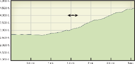
At the junction, turn east (right), and within a few yards you'll see a table-sized
flat boulder shaded by a mesquite tree on the right side of the trail. You're just 300
feet in elevation above the parking lot, so this rock is a good place to sit and consider
whether you have enough water and stamina to climb the steep 1,400 feet from here
to the top.
The trail starts climbing moderately for a few hundred yards and then begins a
series of steep switchbacks up the western nose of the ridge. Sometimes I've been ac-
companied by a raven that likes to hang out around these steep rocks. During the sum-