Travel Reference
In-Depth Information
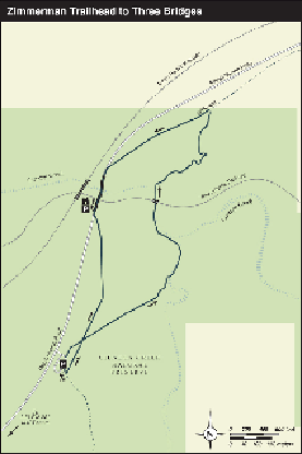
GPS TRAILHEAD COORDINATES:
N32° 00.831' W110° 38.849'
DISTANCE AND CONFIGURATION:
1.8-mile loop
HIKING TIME:
1 hour
HIGHLIGHTS:
Trains, bridges, riparian preserve
ELEVATION:
3,435' at trailhead, 3,325' at Cienega Creek
ACCESS:
Open 24/7; no fees or permits required for trail use; permit required for hiking off-trail
MAPS:
Arizona National Scenic Trail
Passage 8: Rincon Valley
(free PDF at
tinyurl.com/aztpas-
sage8
)
FACILITIES:
Large parking area with 1 picnic table
WHEELCHAIR ACCESS:
From trailhead about 0.1 mile to a memorial view bench
COMMENTS:
This is part of the Arizona National Scenic Trail. Horses, mountain bikes, and
leashed dogs are allowed.
CONTACTS:
Arizona Trail Association, 602-252-4794,
aztrail.org
;
Pima County Natural Re-
sources, Parks and Recreation, 520-877-6158,
pima.gov/nrpr