Travel Reference
In-Depth Information
Overview
Finger Rock is a major landmark on Tucson's mountainous northern horizon. This
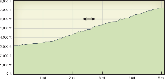
steep, difficult, but clear trail climbs Finger Rock Canyon almost a vertical mile up
into the Catalinas, never getting close to the pinnacle it's named after. Instead, it con-
tinues much higher, reaching a satisfying but uncomplicated summit from which you
can see everything north of Tucson (but not the city itself). You'll enjoy climbing
through changing ecosystems, from stands of saguaro to a pine forest.
Route Details
Start from the Richard “Dick” McKee Trailhead, at the north end of Alvernon Way
about 100 yards from the parking lot. The trailhead's name honors Richard McKee, a
conservationist and member of the Pima County Attorney's Environmental Enforce-
ment Unit, who died in 1999 at age 43 from complications of leukemia. The Finger
Rock Trail was one of his favorite hikes in the Catalinas.
The trailhead, shared with the
Pontatoc Ridge Trail
,
features informative notices
about the bighorn mountain sheep herd that roam the area. They died out in the 1990s,
and a herd of 30 bighorns from Yuma was reintroduced here in November 2013. Two
very short, fairly steep switchbacks bring you to a signed trail fork where Finger
Rock Trail #42 goes north. The trail, nearly flat to begin with, provides great views of
the saguaro-forested lowlands, the digit-in-the-air Finger Rock, and the pine-forested
mound of Mount Kimball to the right of the rock.

