Travel Reference
In-Depth Information
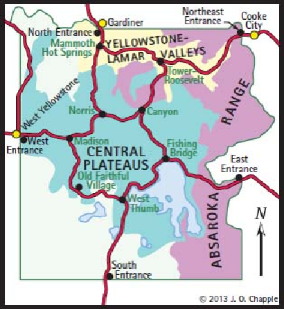
Three Yellowstone Ecosystems
Adapted with permission from
Yellowstone Vegetation: Consequences of Environment and History
in a Natural Setting
(1990), by Don G. Despain.
The map shows the extent of
• the forested community of the central plateaus
• the Yellowstone, Lamar, and Gardner River Valleys, and
• the Absaroka Range ecosystems.
I. THE FORESTED COMMUNITY OF THE CENTRAL PLATEAUS
You're likely to spend the majority of your Yellowstone visit in the central plateaus region,
where most of the roads, the geyser basins, the Yellowstone Canyon, and the western and
northern shores of Yellowstone Lake are found.
The undulating terrain, much of it within the Yellowstone Caldera, consists of rhyolitic
lava and tephra, which weathers to a coarse, sandy soil, poor in nutrients and in ability to hold
water. The altitude in the central plateaus varies from about 6,600 to 8,000 feet (2,000-2,440
m). Precipitation ranges from 20 to 40 inches (50-100 cm) per year.