Travel Reference
In-Depth Information
Swan Lake Flat to Norris Junction
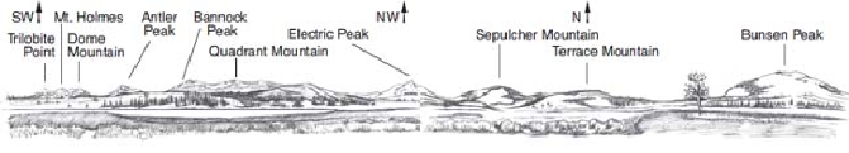
Swan Lake Flat Panorama
Starting to the east (left) and looking around clockwise, you'll see:
To the east and southeast are mountains of the
Washburn Range,
9 to 12 miles (15-19 km)
away.
To the south, the gently rolling terrain is part of the eroded Yellowstone Caldera.
Trilobite Point
(10,011 ft / 3,051 m), a part of Mt. Holmes, the peak farthest to the left. It was
named for ancient trilobite fossils found on the mountain.
Mt. Holmes,
the second highest one in this panorama (10,336 ft / 3,150 m), with a fire lookout
on top and snow near its top most of the year.
Dome Mountain
with two peaks, the higher being 9,903 ft (3,018 m).
Antler Peak
(10,063 ft / 3,067 m), looking very pointed, as elk antlers are.
Bannock Peak
(10,332 ft / 3,149 m)—barely peeking out at Quadrant's left—named for the
tribe who trekked annually through this part of the park to hunt buffalo to the northeast.
For another hike starting here, take the road for about 3 miles (5 km), then descend about
800 feet (250 m) in about 1 mile (1.6 km) on the
Osprey Falls Trail
to the bottom of Sheep-
eater Canyon. Osprey Falls is a 150-foot (46 m) waterfall in a spectacular canyon not seen by
many visitors. You can get a glimpse of the falls from the road.
he
Glen Creek Trail
goes west, starting across the main road from the parking area. It
follows the former Snow Pass Road to join the long Fawn Pass and Sportsman Lake Trails,
which cross the northwest corner of the park, or to meet the Sepulcher Loop Trail up Sep-
ulcher Mountain.
For a delightful, easy 2-mile (3 km) hike, you can take the Glen Creek Trail for a few
hundred yards (meters) until it joins the
Howard Eaton Trail.
Turn right for a gradual ascent
to broad views of Swan Lake Flat and distant mountains to the south. Slightly farther on, you
reach a fine panoramic view toward the Mammoth area to the north.
Quadrant Mountain
(10,213 ft / 3,113 m), the flat-topped ridge in the middle of the view,
named in 1878 by members of the Hayden Survey. Their topographer, Henry Gannett,