Travel Reference
In-Depth Information
The next peak is
Observation Peak
(9,397 ft / 2,864 m), and the higher of the pair to its right
is
Inside Mountain
(9,681 ft / 2,951 m), inside the semicircle of the Washburn Range.
Even as late as mid July, you may see patches of snow. Watch for small waterfalls every-
where. They're pretty to look at, but the water is not safe to drink.
8.6/9.7
Rest area with view to the west.
10.3/8.0
Mount Washburn north side view. Here you see a mountain panorama totally dif-
ferent from the two that are 3 miles north and 4.5 miles south of this point.
13.3/5.0 Dunraven Pass*
(8,873 ft / 2,704 m), the highest point reached by road in the entire
park.
The south end of the
Mount Washburn Trail
is located here.
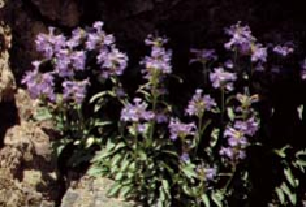
Penstemon
Farther away in the center of the view are
Cook Peak
(9,742 t / 2,969 m) and
Folsom Peak
(9,338 ft / 2,846 m), named for two of the three men who explored and wrote about this
territory in 1869.
On very clear days, you can see
Electric Peak
(10,969 ft / 3,343 m) between Cook and Folsom,
over 20 miles away.
Prospect Peak
(9,525 ft / 2,903 m), named by geologist Arnold Hague in 1885, is closer by on
the right.
Peaks of the
Beartooth Mountains
line the far northern horizon.
No bicycles are allowed on this part of the trail. To hike to the top of Mount Washburn, you
might prefer to start by driving up Chittenden Road (see mile 8.4/9.9) to access a shorter but
steeper route with an elevation gain of 1,500 feet in 2.25 miles (460 m in 3.6 km).