Travel Reference
In-Depth Information
Descending on the Beartooth Highway, you may notice the prominent white ledge across
the wide valley from you. It extends for miles. This is a 100-foot-high (30 m) cliff of Pilgrim
Limestone, over 500 million years old—a very tough sedimentary rock resistant to erosion.
Other limestones and volcanic rocks lie above this layer.
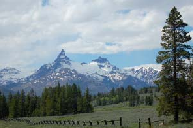
A short side road takes you to an excellent overlook for
Pilot
and
Index Peaks
to the
southwest. Glaciers carved both peaks out of volcanic rocks. Pilot, the pointed one, is a glacial
horn; four glaciers carved its pyramidal shape.
In this area a few snags are left standing from the 1988 Clover-Mist fire that devastated
much of the northeastern quadrant of Yellowstone.
Waterfall enthusiasts should look for the lovely
Lake Creek Falls
on a bend of the old road
that's supported by well-preserved rockwork. It's about 6 miles (10 km) west of the Clay Butte
road. Look for a new bridge and a wide turnout north of the road to find it.
Pilot and Index Peaks have long served as landmarks to explorers and visitors.
About 14 miles (23 km) east of Cooke City is the junction with Wyoming 296, the Chief
Joseph Highway. To continue to the Northeast Entrance, see “The continuation of U.S. 212 to
Cooke City” on
page 198
.
CHIEF JOSEPH SCENIC BYWAY
Instead of taking the Beartooth Highway, you may choose to reach the Northeast Entrance
via another beautiful mountain pass, using Wyoming 296, the Chief Joseph Highway. Dead
Indian Pass (the former name for this entire route) is nearly 3,000 feet (900 m) lower than
Beartooth Pass, so this route receives somewhat less snow and is plowed (though not daily) in
winter.