Travel Reference
In-Depth Information
Turn right (north) out of the West Thumb parking area to continue along the lake toward
Fishing Bridge Junction. The first steam you will see comes from the Lake Shore Group of
thermal features, where there is no public access.
Lone Pine Geyser
in this group has been the
most interesting in recent years. It was known to erupt up to 50 feet (15 m) high, recently per-
forming once a day to once in 36 hours. Lone Pine Geyser's namesake pine tree on a nearby
rock fell into the lake in 1997.
1.8/18.8 Potts Hot Spring Basin
is indicated only by a small widening along the road. Please
heed the Danger—Thermal Area and Do Not Enter signs. This is the northernmost group of
geysers and hot springs of the West Thumb area. The sinter buildup at least 18 feet (5.5 m)
high indicates that it's a very old thermal area.
The Grand Loop Road used to run right through Potts Basin, named for trapper Daniel
Potts, who wrote about his 1826 traverse of this area.
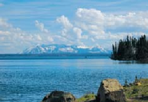
Looking across Bluff Point to Mount Sheridan.
2.4 to 4.2/18.2 to 16.4
Lakeside turnouts near historic
Bluff Point.
3.9/16.7 Carrington Island
is the tiny, rocky bird roost just of shore, submerged at times of
high water except for one tree. It's named after the zoologist of the 1871 Hayden Expedition,
E. Campbell Carrington, who sketched the shoreline of Yellowstone Lake from the first boat
ever known to sail upon it, the
Anna.
Half the nonnative lake trout are believed to spawn near
here.
5.7/14.9
Small parking area on the lake side of the road. One of the two rutted, unmain-
tained trails across the road is a remnant of the main stagecoach road from West Thumb to
Bridge Bay, used from 1902 to 1926. In this area, the builders of the Old Faithful Inn found
some of the strikingly deformed logs used in the inn's interior, according to historian Aubrey
Haines. The other unmaintained trail goes up Arnica Creek to remote Beach Lake.