Travel Reference
In-Depth Information
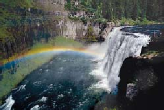
Upper Mesa Falls waters a lush green garden of moss.
There are three Forest Service campgrounds along Idaho 47. Near Warm River, the road
drops steeply over the Henrys Fork Caldera rim. The contrast between forested mountain ter-
rain and gently rolling farmland is sudden and striking. Potatoes, barley, and alfalfa are grown
in these fertile plains. To the east you'll catch views of the Tetons.
Continuing to the Bechler Region
About 6 miles (9.5 km) east of Ashton on Idaho 47, you can take Green Timber Road eastward
to reach Cascade Corner in about another 17 miles (27 km). Before long, the pavement
changes to a good quality gravel surface, just as you enter Caribou-Targhee National Forest.
You cross into Wyoming just before reaching the roads leading to Bechler Ranger Station and
Cave Falls.
The Bechler Region, or Cascade Corner, and Its Water
Named for Gustavus Bechler, a topographer who entered the area with the 1872 Hayden
Expedition, the Bechler Region is best characterized in one word: water. Streams and
marshes are everywhere. The park ranger at Bechler remarked on one June 30: “Bechler
Meadows is a lake!” The whole corner abounds in waterfalls. Within a 10-mile (16 km) ra-
dius of Bechler Ranger Station are Cave, Bechler, and spectacularly beautiful Union Falls
(250 ft / 76 m high), as well as Rainbow, Iris, Colonnade, Ouzel, Dunanda, Silver Scarf, and
Terraced Falls. Farther along the trails are numerous others.
The drawbacks to all this water are several: hikers must wait until the latter part of the
summer to enjoy the area—and even then must be prepared to ford streams that may be as
deep as mid thigh—and mosquitoes and other pesky insects like it here, too. Fortunately,
they die off in late summer.