Agriculture Reference
In-Depth Information
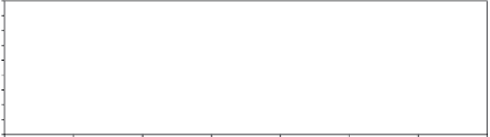
Niamey, Niger
0.45
AVHRR
MODIS
0.40
0.35
0.30
0.25
0.20
0.15
0.10
0.05
0
1980
1985
1990
1995
2000
2005
2010
2015
Ye ar
Modadishu, Somalia
0.45
AVHRR
MODIS
0.40
0.35
0.30
0.25
0.20
0.15
0.10
0.05
0
1980
1985
1990
1995
2000
2005
2010
2015
Ye ar
FIGURE 3.4
Monthly NDVI time series plots from Niamey, Niger and Mogadishu, Somalia,
showing data from the AVHRR and MODIS sensors.
Note
The AVHRR data are available from 1981 and the MODIS-Aqua data from 2002. Both sensors are still in
operation and produce data that can be used for operational drought monitoring.
Unlike rainfall, vegetation data is completely independent of ground observations. Its error
structure is related to land cover and cloudiness, with more humid and tropical ecosystems
having higher errors due to high amounts of atmospheric water vapor and clouds that obscure
the ground during the growing season. Drought-related food security problems are often in
semi-arid and sub-tropical ecosystems with low to moderate errors in satellite-derived
vegetation data (Morisette
et al.
, 2004).
The Visible Infrared Imaging Radiometer Suite (VIIRS) is a new sensor on operational
monitoring satellites that take over the global monitoring task from the AVHRR and MODIS
instruments once they become defunct in the coming years. VIIRS data is used to measure
cloud and aerosol properties, ocean color, sea and land surface temperature, ice motion and
temperature, fires and Earth's albedo. Climatologists use VIIRS data to improve our under-
standing of global climate change.
Maps that show anomalies can be created from these datasets, identifying areas that may be
experiencing drought and that need further examination of potential food security impacts if
the anomaly continues (
Plate 8
). Bringing together information on drought from rainfall data
products with those from vegetation can result in a robust estimation of growing conditions
anywhere in the world.


Search WWH ::

Custom Search