Geology Reference
In-Depth Information
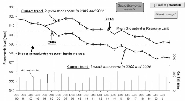
Figure 2.
Simulation of water tables in Maheshwaram watershed according to
Rainfall scenario (substituting the 20 previous rainfall years for the coming
20 years) and a 15-year action plan scenario (decreasing the rice surface area
every two years by 5%, increasing vegetables and flowers surface areas by 10%,
adding a package of solutions, 3 mm/year at the watershed scale).
number of rain harvesting structures (water tanks, dug-wells, etc.) may have
serious negative impacts for the downstream areas.
One of the most interesting options of the developed tool is to assess the
impact of both changing cropping pattern of irrigated culture scenarios and
artificial recharge structure. DST enables the increase or decrease of surface
area of irrigated crops present in the watershed (or other). In order to avoid
non-realistic scenarios, which could not be accepted by the farmers because
of profitability or cultural issues, the DST has been designed to enable the
input of actions plan for several years under various socio-economic criteria.
Figure 3 presents two examples of scenario that considers a 15-year action
plan scenario (from 2005 to 2019) where there is 6% decrease of the rice
cultivated area every two years and at the same time 20% increase of
vegetables and flowers cultivated area. In this scenario paddy field area is
reduced by 40% and area of vegetables and flowers is increased by 30% at
the end of the plan.
The first scenario (scenario 1) considers the changing cropping pattern
only and in the second (scenario 2) artificial recharge structures have been
added, the recharge rate being 2 mm/year at the watershed scale. This 2 mm/
year may correspond to about 25 hectares of additional tanks or about 30
defunct dug-wells where run off is diverted (dug-well dimension: 10 × 10 ×
13 m; supposed fully-filled up three times a year); moreover it might be the
improvement of irrigation techniques or consequences of a public awareness
programme (water conservation). While scenario 1 is just able to maintain
the mean groundwater level above the mean groundwater resource limit,