Environmental Engineering Reference
In-Depth Information
In 1984, the USAF accepted responsibility for remediation activities south of Los Reales Road. An
informal agreement was reached among the USAF, Hughes, the USEPA, and the Arizona Department
of Health Services (ADHS) to begin groundwater remediation at AFP 44 i rst, with subsequent
historical disposal site/source area investigation and remediation. The USAF was also party to an
agreement and provided funding for design, installation, and operation of an extraction well i eld
and treatment plant to replace the lost water supply capacity for the City of Tucson.
8.7.2 G
EOLOGIC
AND
H
YDROGEOLOGIC
S
ETTING
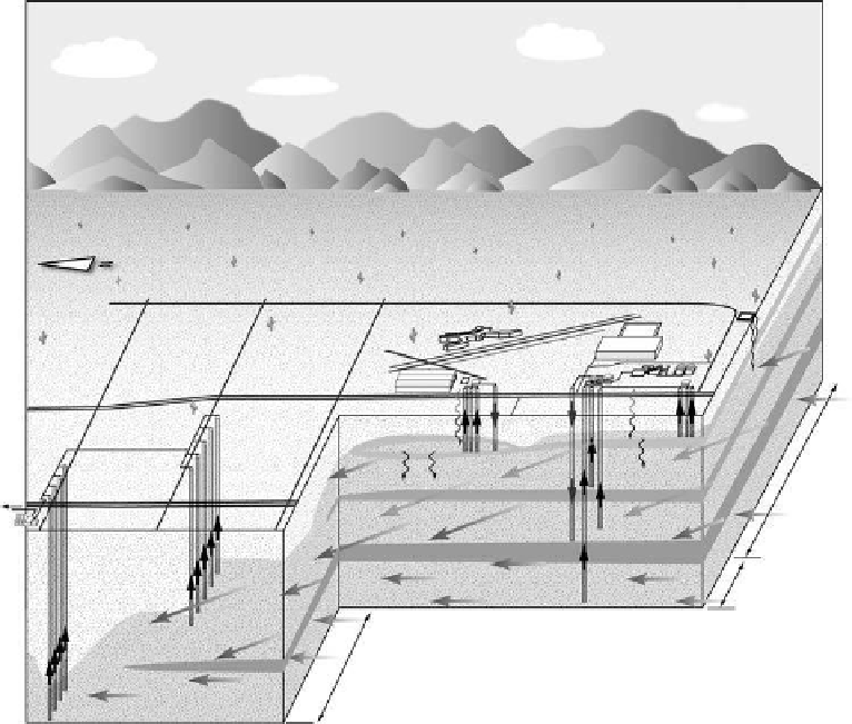
Groundwater beneath AFP 44 occurs within Tucson Basin alluvial sediments, starting at depths of
90-140 ft bgs. Figure 8.10 presents a conceptual site model intended to schematically portray the
various water-bearing units and potential migration pathways for 1,4-dioxane at the site. The unsat-
urated zone above the regional aquifer is made up of discontinuous sand and gravel lenses interbed-
ded with layers of sandy clay, clayey sand, and clay. The material is unconsolidated except where
cemented with caliche. A continuous stratum of reddish brown sandy clay and clay occurs between
about 80 and 130 ft deep and is locally referred to as the upper clay unit. In the northwestern portion
of AFP 44, perched groundwater is present above and within the upper clay unit in an area referred
to as the “Shallow Groundwater Zone (SGZ).”
The regional aquifer beneath the site consists of an upper and a lower-aquifer zone separated by
a thick, laterally extensive, clay aquitard. The upper zone extends down to the contact with the clay
Tu c s o n
airport
Site 5
FA C O
site 2
Bldg 801
?
TI zone
Site 3
GWTP
SGZ DPE
SGZ DPE
3 hangars
Old Nogales highway
?
?
?
North
well
field
Gravel subunit (GSU)
200 gpm
Cienega
creek
fan
deposits
?
70 gpm
South
well field
To
drinking
water
supply
?
?
I-19
TARP
?
2000 gpm
Catalina river
deposits
800 gpm
Lower aquifer zone
Upper aquifer
zone
(undifferentiated)
Undivided
regional
aquifer
Catalina river
deposits
4000 gpm
Not to scale
FIGURE 8.10
Schematic conceptual site model for Air Force Plant 44.
Search WWH ::

Custom Search