Biology Reference
In-Depth Information
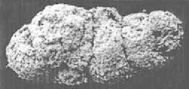
Figure 3.9
Coprolite from the
Santonian (Late Cretaceous)
of Georgia, USA, similar to
those of modern beetle and
containing
Noferinia
pollen.
From Lupia and others 2002.
Used with permission from the
University of Chicago Press,
Chicago.
and biochemical fossils (Eglinton and Eglinton 2008) such as the long-
chain alkenones produced by algae and preserved in marine sediments.
Fossil-based biostratigraphy, lithostratigraphy (rock based), and magneto-
stratigraphy are among the multiple ways of arranging strata and placing the
history of the planet and the life it supports in proper chronological order.
Seismic/Sequence Stratigraphy and Facies
Different kinds of sediments are deposited in a fl uctuating environment.
For example, during periods of ingression and regression along a shoreline,
silts with marine organisms, lignites with pollen of terrestrial vegetation,
and sandstones and conglomerates from exposed erosion layers may alter-
nate in repeating cycles with the coming and going of the waters. These
layers, representing different depositional environments, are called facies,
and their subsurface arrangement, extent, thickness as indicated by zones
of separation between them (unconformities), and distortion by faulting,
compression, transpression (oblique collision), extension (stretching), and
overturning is revealed in seismic refl ection profi les. These profi les are pro-
duced by sending sound waves, generated by explosives on land, or by air
guns at sea, through the Earth's crust and reading the refl ection times back
to the surface with geophones or hydrophones. The time it takes for the
waves to return is a function of the density and thickness of the subsurface
layers. In combination with visible samples from drill cores, and study of
exposures on deep canyon walls, the kind of rock composing these layers
can be identifi ed (e.g., sedimentary sandstone, limestone, shale; igneous
lava intrusions; metamorphics such as anthracite coal, graphite, marble,
and slate). The technique is applicable to a depth of about 5 km and it has
a resolution of about 15 m. It is another method in the impressive arsenal
used to establish the relative age of rocks.