Environmental Engineering Reference
In-Depth Information
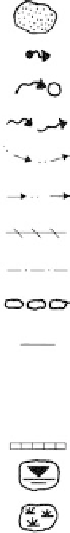
TOPOGRAPHY
Ground Profile
OTHER FEATURES
Symbol
convex
well defined or angular
break of slope
Boulder
concave
Seepage/spring
convex
concave
poorly defined or
smooth change of slope
Swallow hole for runoff
Natural water course
breaks of slope
changes of slope
convex and concave too close together
to allow the use of separate symbols
Open drain, unlined
Open drain, lined
L
L
sharp
rounded
Fenceline
ridge crest
Property boundary
Dry Stone Wall
Cliff or escarpment or sharp break
40º or more (estimated height in metres)
3
J
J
Major joint in rock face
(opening in millimetres)
Tension crack
(opening in millimetres)
Masonry or concrete wall
15
200
Uniform Slope
10
Concave Slope
Slope direction and angle (Degrees)
- T - T -
10
8
Convex Slope
Top
Ponding water
Cut or fill slope, arrows pointing down slope
Bottom
Boggy or swampy area
Hummocky or irregular ground
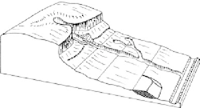
EXAMPLE OF USE OF TOPOGRAPHIC SYMBOLS:
BLOCK DIAGRAM
GEOTECHNICAL
PLAN
6
5
14
3
2
5
1
7
12
5
1
4
3
2
4
2
Figure 5.4.
Geomorphological mapping symbols (Courtesy Jeffery and Katauskas).