Environmental Engineering Reference
In-Depth Information
(APHA, AWWA, WEF; 20th ed., 1998 and 1991 supplement) can also be consulted.
Numerous methods for sampling and assessment are available from the American Society
for Testing Materials (ASTM). (See Appendix B.) For health and safety issues related to
sampling, the Occupational Health and Safety Administration (OSHA), particularly
OSHA-29 CFR 1910.120, should be examined. Also in the United States, each state has
its own environmental protection agency (EPA), which will have state-specific
regulations for such things as sampling [2-4]. Most countries will have similar
organizations, and these must be consulted.
5.2.
GLOBAL POSITIONING SYSTEM
It is highly recommended that GPS be used in locating sample sites. As discussed in
Chapter 3, the first step in sampling is to set up the coordinates for the field. This means
first deciding which coordinate system to use and finding the coordinates at the corners
and edges of the field. These are then put on the maps of the fields, which are then used
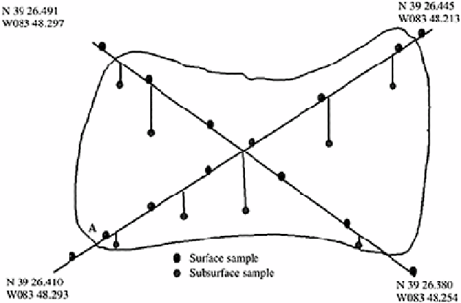
for all other sampling activities. Maps such as those shown in Figures 5.1 to 5.3 should
include these coordinate references at each corner as shown, because these locate the
field unequivocally.
A GPS works using satellites in orbit around the Earth. These satellites transmit signals
that are received by GPS units on the Earth. Using a minimum of two signals, a GPS unit
can show where it is located on the Earth's surface. (It is highly recommended, however,
that a unit accessing twelve or more satellites be used.) This system can also give the
FIGURE 5.1
Transect sampling. The curved line encloses the suspected
contaminated area. Note that the samples along the transect lines are
taken randomly.
Search WWH ::

Custom Search