Geoscience Reference
In-Depth Information
areas to the west. Therefore, the geologic structure of the Tenryu canyon area likely
influences the seismogenic behavior of the eastern Nankai accretionary prism.
2
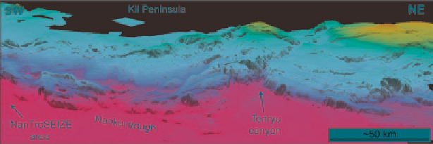
Tenryu Canyon
Tenryu canyon cuts deeply into the eastern edge of the Nankai accretionary prism
(Fig.
2
). Originating as the drainage for the Tenryu river at the coastline, the south-
ern mouth of the canyon opens to the trench roughly 130 km to the south at roughly
3,800 m below sea-level (mbsl). The geomorphology of Tenryu canyon is character-
ized by steep walls that can be more than 500 m high over similar lateral distances.
The morphology of the canyon has been interpreted to signify subsidence of the
Nankai trough below the 'antecedent' submarine drainage following subduction of
a seamount or an earlier equivalent to the Zenisu ridge (Soh and Tokuyama
2002
).
The surface of the accretionary prism in the Tenryu canyon area is cut by several
well-mapped, scarp-forming, and seismically imaged faults, including the frontal
thrust of the accretionary prism and the Tokai thrust. The Tokai thrust is a prominent
out-of-sequence fault that is likely the along-strike structural equivalent to the out-
of-sequence 'megasplay' thrust fault in the NanTroSEIZE area. The NanTroSEIZE
megasplay fault is likely the up-dip expression of the seismogenic and tsunamigenic
fault associated with the Tonankai (1946) earthquake (Park et al.
2002
; Nakanishi
et al.
2002a, b
; Moore et al.
2007
). In the Tenryu canyon area the seismogenic his-
tory of the Tokai thrust is less certain, and the fault appears to laterally ramp or
possibly begin to tip out between two 2D seismic sections (Takahashi et al.
2002
).
The Tokai thrust roughly bounds an area where samples of late Pliocene, low-
porosity, high-strength phyllite were collected by Kawamura et al. (
2009
). These rela-
tively consolidated samples contrast with the surrounding <180-480 ka, high porosity
and low strength sediments that dominate the area. Kawamura et al. (
2009
) suggest
that the Tokai thrust may therefore have exhumed deeper prism material. We offer an
additional hypothesis that the phyllite samples collected by Kawamura et al. (
2009
)
could also represent kinematically independent slivers of material that were deformed
and metamorphosed in response to frictional heating and/or enhanced water-rock
reactions within the fault zone, though more work is required to test this hypothesis.
Fig. 2
Oblique, westerly perspective of the Nankai margin and Tenryu canyon area. Note the
large bathymetric high (
red
) on the northern edge of Tenryu canyon, and the more northerly strik-
ing ridges on the west side
Search WWH ::

Custom Search