Geoscience Reference
In-Depth Information
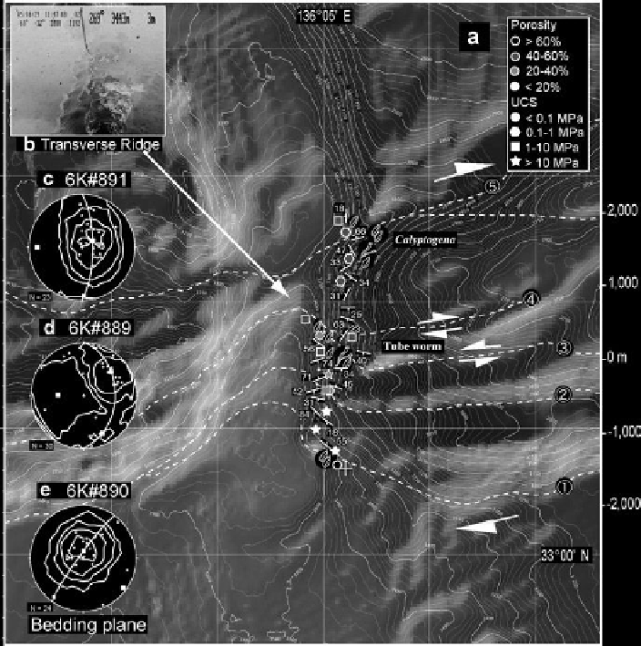
Fig. 5
Geologic structures of the megasplay fault zone (Data source; Anma et al.
2010
). (
a
) Map
area is indicated in Fig.
1b
. Numbers along the NS axis indicate distance (m) from a reference point
on 33
o
01.6¢N and are used in Fig.
7
. (
b
) Outcrop of siltstone at the site 889R1 (FOV ~ 2 m). This
outcrop was observed at the leeward slope of the transverse ridge developed across the mid axis of
the canyon. The transverse ridge is considered to be of tectonic origin. (
c
) Stereonet plot of S-poles
to bedding planes of the northern domain (6K#891 area) are open-folded about an axis plunging 17°
to the west. (
d
) Bedding in the central domain (6K#889 area) folded about an axis plunging 50° to
the west. (
e
) Bedding planes of the southern domain (6K#890 area) plot around a sub-horizontal
point maximum
Overall structures of this area (Fig.
3d
) suggest an anticlinal fold with km-scale
wavelength and southward vergence (Fig.
7a
). The strata become younger toward
the south from the hinge of the anticlinal fold (Fig.
7a
). In addition, folds with
shorter wavelength (~200 m) are developed in the landward (rear) part of the 5th
ridge south of the boundary fault. Two sets of joints are developed in the folded
turbidite sequence: one trending NS and the other trending WNW-ESE (Fig.
3d
).
Fractures are less developed in conglomerates that cover the turbidite sequence.
Search WWH ::

Custom Search