Geoscience Reference
In-Depth Information
a
35˚N
30˚N
Shikoku Basin
25˚N
20˚N
Parece
Vela
Basin
West Philippine Basin
15˚N
10˚N
5˚N
120˚E
125˚E
130˚E
135˚E
140˚E
145˚E
150˚E
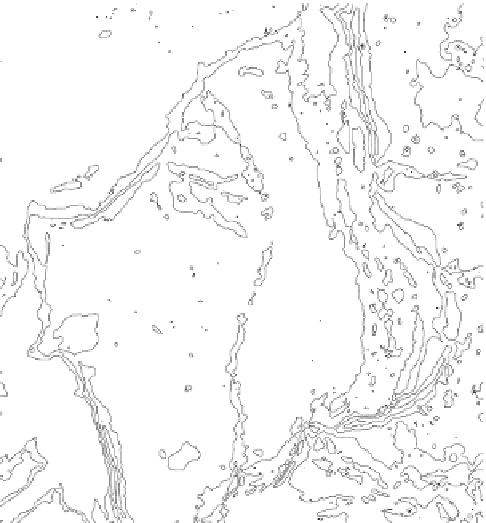
Fig. 1
(
a
) Index map showing the location of the Parece Vela Basin. The
box
indicates the loca-
tion of (
b
). The
gray rectangular
indicates the location of Godzilla Megamullion. (
b
) Structural
image of the Parece Vela Basin illuminated from 90° based on Ohara et al. (
2001
).
Dashed yellow
lines
are the magnetic anomaly isochrons with anomaly number taken from Okino et al. (
1998
).
Chron 7 corresponds to 26 Ma, and Chron 6A corresponds to 21 Ma (Okino et al.
1998
). The
short, first-order segments of the Parece Vela Rift are labeled as S1-S7 from south to north (Ohara
et al.
2001
). The Chaotic Terrain is indicated by a
thick dashed line
. Godzilla Megamullion is
developed at segment S1. Some pseudofaults (indicated by
dotted lines
) suggest ridge propagation
and jump occurred there (Okino et al.
1998
)
the area, as well as to provide a better understanding of the convergent margin
tectonics in the Northwest Pacific.
2
Oceanic Core Complexes
Oceanic core complexes (OCCs) are domal bathymetric highs, generally characterized
by axis-normal corrugations, higher mantle Bouguer anomalies, and peridotite and
gabbro exposures. OCCs have been recognized mostly along slow-spreading ridges;
these occurrences in intermediate- and ultraslow-spreading ridges are less common
(e.g., Tucholke et al.
2008
; Blackman et al.
2009
). OCCs are interpreted as exhumed


Search WWH ::

Custom Search