Environmental Engineering Reference
In-Depth Information
4.7 Southern Mediterranean mountains: Atlas
Mountains and Iberian Baetic Cordillera
4.7.1 The Atlas
The Atlas mountain system in northwest Africa spans Morocco, Algeria and
Tunisia. It is limited to the south by the Sahara desert, and to the north and west by
the Mediterranean sea and Atlantic Ocean. Stretching for approximately 2500 km
from southwestern Morocco to northern Tunisia, it forms a topographic and climatic
barrier between the Mediterranean and the Sahara. It is part of the great Alpine-
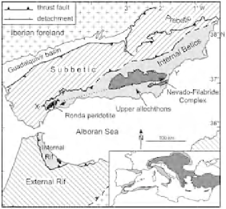
Himalayan folding: on the one hand, through the Rif, the Atlas can be considered
as an extension of the Baetic system in the Iberian peninsula (Figure 4.1), while in
its eastern section it is connected, under the Sicilian Channel, to the Italian Apen-
nine system. In the Atlas traces of Precambrian and Caledonian bending are recog-
nizable. The Hercynian orogeny later gave rise to the formation of a grand chain
directed from north to south; its existence was short-lived, however, as it was al-
ready eroded and peneplanated by the end of the Palaeozoic. During the Mesozoic
and Cenozoic, thick layers of sandstone, limestone and schist were deposited on top
of this base, and then were folded during the Alpine orogeny. The first phase of this
orogeny (Pyrenean phase) is of Eocene age and the hills were quickly eroded. Dur-
ing the Miocene the main orogenic phase occurred, which gave the Atlas its current
configuration.
The structure of the Atlas system is quite complex. On its eastern side, there are
two main mountain ranges, the northern coastal Atlas Tell, and the southern interior
Saharan Atlas. The first extends parallel to the coast of Algeria, from the Gulf of
Annaba to the border of Morocco. It is characterized structurally by overlapping
Figure 4.1
Tectonic map of Baetic-Rif arc. Reproduced from Platt
et al.
(2006), with permission