Travel Reference
In-Depth Information
Even though the mile posts start at the southern terminus of the trail, it's best
to start your trip on the slightly uphill grade at the northern terminus at Cass Scenic
Railroad State Park and follow the river downstream. The first town you will pass is
Clover Lick, a lovely little Appalachian town with rustic remnants of the old railroad
depot that once served the booming logging industry.
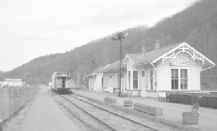
The Marlinton Depot on the Greenbrier River Trail serves as a trailside museum with
exhibits on the former railroad.
Beyond the Clover Lick trailhead, the trail proceeds south, winding 20 miles
downstream through some of the most scenic and remote wilderness landscapes in
West Virginia. This section ends at the only large town you will encounter along the
trail, Marlinton, which hosts some great lunch spots and bed-and-breakfasts. You can
find a trailside information center in Marlinton's old train station near mile 55. As
you proceed south from Marlinton, you will cross the river twice before reaching the
halfway point at Beard.
Beyond Beard, at mile marker 31, is one of the trails' two spectacular tunnels:
the 402-foot-long Droop Mountain Tunnel, built in 1900. The other is Sharps Tunnel,
just beyond mile point 65. Work began on the impressive, 511-foot-long structure in
1899. These tunnels are a reminder: One of the great things about the Greenbrier is
the opportunity to see remnants of the old railroad, including the many whistleposts
and historical mile markers.
Continuing south, beyond Anthony (at mile 15), the trail crosses two former rail-
road bridges and eventually reaches its southern terminus at North Caldwell (mile
post 3). This trailhead is located just outside Lewisburg, which has a variety of shops,
restaurants, and lodging establishments.